SUPPORT TRACK THE TROPICS
Over the last decade plus if you appreciate the information and tracking I provide during the season along with this website which donations help keep it running please consider a one time... recurring or yearly donation if you are able to help me out...
Venmo: @TrackTheTropicsLouisiana
Website: TrackTheTropics.com/DONATE
Venmo: @TrackTheTropicsLouisiana
Website: TrackTheTropics.com/DONATE
Track The Tropics is the #1 source to track the tropics 24/7! Since 2013 the main goal of the site is to bring all of the important links and graphics to ONE PLACE so you can keep up to date on any threats to land during the Atlantic Hurricane Season! Hurricane Season 2025 in the Atlantic starts on June 1st and ends on November 30th. Do you love Spaghetti Models? Well you've come to the right place!! Remember when you're preparing for a storm: Run from the water; hide from the wind!
Tropical Atlantic Weather Resources
- NOAA National Hurricane Center
- International Meteorology Database
- FSU Tropical Cyclone Track Probabilities
- Brian McNoldy Atlantic Headquarters
- Brian McNoldy Tropical Satellite Sectors
- Brian McNoldy Infrared Hovmoller
- Brian McNoldy Past TC Radar Loops
- Weather Nerds TC Guidance
- Twister Data Model Guidance
- NOAA Tropical Cyclone Tracks
- Albany GFS/ EURO Models/ Ensembles
- Albany Tropical Cyclone Guidance
- Albany Tropical Atlantic Model Maps
- Pivotal Weather Model Guidance
- Weather Online Model Guidance
- UKMet Model Guidance/ Analysis/ Sat
- ECMWF (EURO) Model Guidance
- FSU Tropical Model Outputs
- FSU Tropical Cyclone Genesis
- Penn State Tropical E-Wall
- NOAA HFIP Ruc Models
- Navy NRL TC Page
- College of DuPage Model Guidance
- WXCharts Model Guidance
- NOAA NHC Analysis Tools
- NOAA NHC ATCF Directory
- NOAA NCEP/EMC Cyclogenesis Tracking
- NOAA NCEP/EMC HWRF Model
- NOAA HFIP Model Products
- University of Miami Ocean Heat
- COLA Max Potential Hurricane Intensity
- Colorado State RAMMB TC Tracking
- Colorado State RAMMB Floaters
- Colorado State RAMMB GOES-16 Viewer
- NOAA NESDIS GOES Satellite
- ASCAT Ocean Surface Winds METOP-A
- ASCAT Ocean Surface Winds METOP-B
- Michael Ventrice Waves / MJO Maps
- TropicalAtlantic.com Analysis / Recon
- NCAR/RAL Tropical Cyclone Guidance
- CyclonicWX Tropical Resources
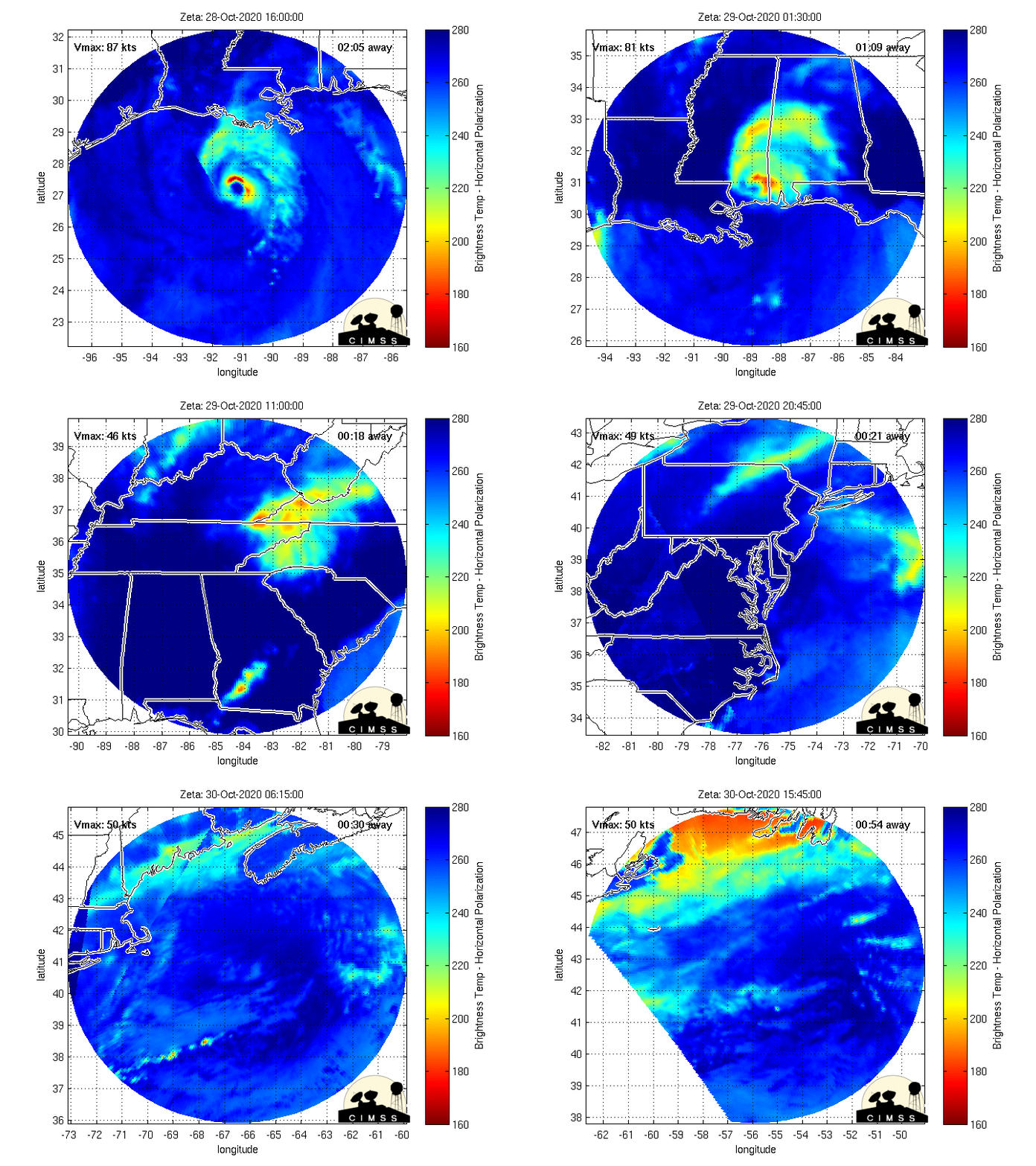
Tropical Storm Zeta – 2020 Hurricane Season
NHC Important Links: NHC Discussion / NHC Public Advisory / NHC Forecast / Wind Probs / Storm Archive
Important LOCAL Links: NWS New Orleans/ Baton Rouge / NWS Mobile/ Pensacola / Loops of Laura / Power Outages
Storm Tracking Important Links:
FSU Track Probability /
NOAA Tracker /
Albany Tracker /
Navy NRL Page /
HFIP Products /
TropicalAtlantic Tracker /
NCAR Guidance Page /
CyclonicWX Tracker Products /
CIMSS Tracker / TropicalTidbits Tracker / UWM Tracker / SFWMD Models
Peak Storm Surge Forecast

Potential Storm Surge Flooding Map (Inundation)
Additional Potential Storm Surge Map

Potential Storm Surge Flooding Map (Inundation)
Additional Potential Storm Surge Map
- Sat, 05 Jul 2025 17:35:24 +0000: Atlantic Tropical Storm Chantal Intermediate Advisory Number 4a - Atlantic Tropical Storm Chantal Intermediate Advisory Number 4a
000
WTNT33 KNHC 051735
TCPAT3
BULLETIN
Tropical Storm Chantal Intermediate Advisory Number 4A
NWS National Hurricane Center Miami FL AL032025
200 PM EDT Sat Jul 05 2025
...CHANTAL STRENGTHENS...
...TROPICAL STORM CONDITIONS EXPECTED TO BEGIN IN THE WARNING AREA
THIS EVENING...
SUMMARY OF 200 PM EDT...1800 UTC...INFORMATION
----------------------------------------------
LOCATION...31.6N 78.7W
ABOUT 105 MI...175 KM SE OF CHARLESTON SOUTH CAROLINA
ABOUT 185 MI...300 KM SSW OF WILMINGTON NORTH CAROLINA
MAXIMUM SUSTAINED WINDS...45 MPH...75 KM/H
PRESENT MOVEMENT...N OR 360 DEGREES AT 3 MPH...6 KM/H
MINIMUM CENTRAL PRESSURE...1006 MB...29.71 INCHES
WATCHES AND WARNINGS
--------------------
CHANGES WITH THIS ADVISORY:
None.
SUMMARY OF WATCHES AND WARNINGS IN EFFECT:
A Tropical Storm Warning is in effect for...
* South Santee River, SC to Surf City, NC
A Tropical Storm Watch is in effect for...
* Edisto Beach to South Santee River, SC
A Tropical Storm Warning means that tropical storm conditions are
expected somewhere within the warning area, in this case within
the next 12 hours
A Tropical Storm Watch means that tropical storm conditions are
possible within the watch area, in this case within the next 12
hours.
Interests elsewhere along the southeast coast of the United States
should monitor the progress of Chantal.
For storm information specific to your area, including possible
inland watches and warnings, please monitor products issued by your
local National Weather Service forecast office.
DISCUSSION AND OUTLOOK
----------------------
At 200 PM EDT (1800 UTC), the center of Tropical Storm Chantal was
located near latitude 31.6 North, longitude 78.7 West. Chantal is
moving toward the north near 3 mph (6 km/h). A motion toward the
north-northwest is expected to begin later today, followed by a turn
to the northeast by Sunday night. On the forecast track, the center
of Chantal is expected to move across the coast of South Carolina
overnight or early Sunday morning.
Maximum sustained winds have increased to near 45 mph (75 km/h) with
higher gusts. Some additional strengthening is expected before
Chantal reaches the coast.
Tropical-storm-force winds extend outward up to 105 miles (165 km)
primarily to the east of the center.
The estimated minimum central pressure based on aircraft data is
1006 mb (29.71 inches).
HAZARDS AFFECTING LAND
----------------------
Key messages for Tropical Storm Chantal can be found in the
Tropical Cyclone Discussion under AWIPS header MIATCDAT3 and WMO
header WTNT43 KNHC.
WIND: Tropical storm conditions are expected in the warning area
beginning this evening and continuing through Sunday morning.
Tropical storm conditions are possible in the watch area beginning
later today.
RAINFALL: Tropical Storm Chantal is expected to produce heavy
rainfall across portions of the coastal plain of the Carolinas
through Monday. Storm total rainfall of 2 to 4 inches, with local
amounts up to 6 inches, is expected and these rains could cause
flash flooding.
For a complete depiction of forecast rainfall and flash flooding
associated with Tropical Storm Chantal, please see the National
Weather Service Storm Total Rainfall Graphic, available at
hurricanes.gov/graphics_at3.shtml?rainqpf
STORM SURGE: The combination of storm surge and tide will cause
normally dry areas near the coast to be flooded by rising waters
moving inland from the shoreline. The water could reach the
following heights above ground somewhere in the indicated areas if
the peak surge occurs at the time of high tide...
South Santee River, SC to Surf City, NC...1-3 ft
Edisto Beach, SC to South Santee River, SC...1-2 ft
TORNADOES: Isolated tornadoes are possible tonight into Sunday
along the coast of eastern South Carolina and much of North
Carolina.
SURF: The tropical storm is expected to bring life-threatening
surf and rip currents along the coast from northeastern Florida to
the Mid-Atlantic states during the next couple of days.
A depiction of rip current risk for the United States can be found
at: hurricanes.gov/refresh/graphics_at3+shtml/?ripCurrents
NEXT ADVISORY
-------------
Next complete advisory at 500 PM EDT.
$$
Forecaster Cangialosi/Konarik
- Sat, 05 Jul 2025 14:53:53 +0000: Atlantic Tropical Storm Chantal Forecast/Advisory ... - Atlantic Tropical Storm Chantal Forecast/Advisory Number 4
000
WTNT23 KNHC 051453
TCMAT3
TROPICAL STORM CHANTAL FORECAST/ADVISORY NUMBER 4
NWS NATIONAL HURRICANE CENTER MIAMI FL AL032025
1500 UTC SAT JUL 05 2025
TROPICAL STORM CENTER LOCATED NEAR 31.1N 78.7W AT 05/1500Z
POSITION ACCURATE WITHIN 30 NM
PRESENT MOVEMENT TOWARD THE NORTH OR 10 DEGREES AT 1 KT
ESTIMATED MINIMUM CENTRAL PRESSURE 1007 MB
MAX SUSTAINED WINDS 35 KT WITH GUSTS TO 45 KT.
34 KT....... 80NE 80SE 0SW 0NW.
4 M SEAS.... 60NE 60SE 0SW 0NW.
WINDS AND SEAS VARY GREATLY IN EACH QUADRANT. RADII IN NAUTICAL
MILES ARE THE LARGEST RADII EXPECTED ANYWHERE IN THAT QUADRANT.
REPEAT...CENTER LOCATED NEAR 31.1N 78.7W AT 05/1500Z
AT 05/1200Z CENTER WAS LOCATED NEAR 30.8N 79.0W
FORECAST VALID 06/0000Z 31.8N 79.0W
MAX WIND 45 KT...GUSTS 55 KT.
34 KT... 80NE 80SE 0SW 20NW.
FORECAST VALID 06/1200Z 33.1N 79.3W...INLAND
MAX WIND 45 KT...GUSTS 55 KT.
34 KT... 80NE 80SE 0SW 20NW.
FORECAST VALID 07/0000Z 34.6N 79.2W...INLAND
MAX WIND 30 KT...GUSTS 40 KT.
FORECAST VALID 07/1200Z 35.8N 78.0W...POST-TROP/INLAND
MAX WIND 30 KT...GUSTS 40 KT.
FORECAST VALID 08/0000Z...DISSIPATED
REQUEST FOR 3 HOURLY SHIP REPORTS WITHIN 300 MILES OF 31.1N 78.7W
INTERMEDIATE PUBLIC ADVISORY...WTNT33 KNHC/MIATCPAT3...AT 05/1800Z
NEXT ADVISORY AT 05/2100Z
$$
FORECASTER CANGIALOSI
- Sat, 05 Jul 2025 14:55:52 +0000: Atlantic Tropical Storm Chantal Discussion Number 4 - Atlantic Tropical Storm Chantal Discussion Number 4
000
WTNT43 KNHC 051455
TCDAT3
Tropical Storm Chantal Discussion Number 4
NWS National Hurricane Center Miami FL AL032025
1100 AM EDT Sat Jul 05 2025
Satellite images suggest that Chantal has been organizing and
gaining strength. The storm is still asymmetric though, with most
of the associated showers and thunderstorms located near and to the
east of the center. The Air Force Hurricane Hunters are currently
investigating the system and have found that the pressure has
dropped to 1007 mb. The plane has yet to sample the area of strong
thunderstorms, where the highest winds are likely occurring. The
initial intensity is set at 35 kt for now. The outer rainbands are
beginning to reach portions of South and North Carolina, and
conditions along the coast within the watch and warning areas are
expected to continue to deteriorate throughout the day.
Chantal has barely moved since last night, but a motion to the
north-northwest is expected to begin soon. The main steering
features appear to be a mid- to upper-level low over the Gulf and a
narrow mid-level ridge across the mid-Atlantic region. The flow
between these features should cause Chantal to move inland over
South Carolina Sunday morning. It should be noted that center
reformations are possible, which could cause some erratic motion.
After landfall, a turn to the northeast is expected when the storm
moves on the western side of the ridge. The NHC track forecast lies
close to the previous one, and the latest HCCA and Google Deep Mind
solutions.
Additional strengthening seems likely in the short term as Chantal
is expected to remain over warm water and move into a lower wind
shear environment. In addition, the shear direction is expected to
shift from southwesterly to southerly, which is more conducive for
strengthening. The NHC intensity forecast is a little higher than
the previous one, and in line with the latest HMON, HAFS-A, and
HAFS-B guidance. After landfall, steady weakening is expected until
the system dissipates in 48 to 60 hours.
Chantal is expected to remain a lopsided system during the next day
or so. Therefore, the strongest winds are anticipated to occur to
the right of the landfall location.
Key Messages:
1. Tropical storm conditions are expected in the warning area
beginning this evening and continuing through Sunday morning.
2. Heavy rainfall across the coastal Carolinas will cause some flash
flooding through Monday. Isolated to scattered flash flooding could
occur within more urbanized areas in the coastal plain of the
Carolinas.
3. Chantal is expected to bring life-threatening surf and rip
currents along the coast from northeastern Florida to the
Mid-Atlantic states during the next couple of days. Beach goers
should heed the advice of lifeguards and local officials.
FORECAST POSITIONS AND MAX WINDS
INIT 05/1500Z 31.1N 78.7W 35 KT 40 MPH
12H 06/0000Z 31.8N 79.0W 45 KT 50 MPH
24H 06/1200Z 33.1N 79.3W 45 KT 50 MPH...INLAND
36H 07/0000Z 34.6N 79.2W 30 KT 35 MPH...INLAND
48H 07/1200Z 35.8N 78.0W 30 KT 35 MPH...POST-TROP/INLAND
60H 08/0000Z...DISSIPATED
$$
Forecaster Cangialosi/Konarik


 DONATE
