401 Visitors Tracking The Tropics!
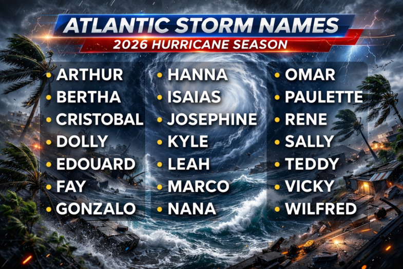
Track The Tropics is the #1 source to track the tropics 24/7! Since 2013 the main goal of the site is to bring all of the important links and graphics to ONE PLACE so you can keep up to date on any threats to land during the Atlantic Hurricane Season! Hurricane Season 2026 in the Atlantic starts on June 1st and ends on November 30th. Do you love Spaghetti Models? Well you've come to the right place!! Remember when you're preparing for a storm: Run from the water; hide from the wind!
Tropical Atlantic Weather Resources
- NOAA National Hurricane Center
- International Meteorology Database
- FSU Tropical Cyclone Track Probabilities
- Brian McNoldy Atlantic Headquarters
- Brian McNoldy Tropical Satellite Sectors
- Brian McNoldy Infrared Hovmoller
- Brian McNoldy Past TC Radar Loops
- Weather Nerds TC Guidance
- Twister Data Model Guidance
- NOAA Tropical Cyclone Tracks
- Albany GFS/ EURO Models/ Ensembles
- Albany Tropical Cyclone Guidance
- Albany Tropical Atlantic Model Maps
- Pivotal Weather Model Guidance
- Weather Online Model Guidance
- UKMet Model Guidance/ Analysis/ Sat
- ECMWF (EURO) Model Guidance
- FSU Tropical Model Outputs
- FSU Tropical Cyclone Genesis
- Penn State Tropical E-Wall
- NOAA HFIP Ruc Models
- Navy NRL TC Page
- College of DuPage Model Guidance
- WXCharts Model Guidance
- NOAA NHC Analysis Tools
- NOAA NHC ATCF Directory
- NOAA NCEP/EMC Cyclogenesis Tracking
- NOAA NCEP/EMC HWRF Model
- NOAA HFIP Model Products
- University of Miami Ocean Heat
- COLA Max Potential Hurricane Intensity
- Colorado State RAMMB TC Tracking
- Colorado State RAMMB Floaters
- Colorado State RAMMB GOES-16 Viewer
- NOAA NESDIS GOES Satellite
- ASCAT Ocean Surface Winds METOP-A
- ASCAT Ocean Surface Winds METOP-B
- Michael Ventrice Waves / MJO Maps
- TropicalAtlantic.com Analysis / Recon
- NCAR/RAL Tropical Cyclone Guidance
- CyclonicWX Tropical Resources
Historic Louisiana Storms By Month
January
June
July
August
September
October
Tropical Cyclone Structure

The Eye
The hurricane's center is a relatively calm, generally clear area of sinking air and light winds that usually do not exceed 15 mph (24 km/h) and is typically 20-40 miles (32-64 km) across. An eye will usually develop when the maximum sustained wind speeds go above 74 mph (119 km/h) and is the calmest part of the storm. But why does an eye form? The cause of eye formation is still not fully understood. It probably has to do with the combination of "the conservation of angular momentum" and centrifugal force. The conservation of angular momentum means is objects will spin faster as they move toward the center of circulation. So air increases it speed as it heads toward the center of the tropical cyclone. One way of looking at this is watching figure skaters spin. The closer they hold their hands to the body, the faster they spin. Conversely, the farther the hands are from the body the slower they spin. In tropical cyclone, as the air moves toward the center, the speed must increase.
 This sinking air suppresses cloud formation, creating a pocket of generally clear air in the center. People experiencing an eye passage at night often see stars. Trapped birds are sometimes seen circling in the eye, and ships trapped in a hurricane report hundreds of exhausted birds resting on their decks. The landfall of hurricane Gloria (1985) on southern New England was accompanied by thousands of birds in the eye.
The sudden change of very strong winds to a near calm state is a dangerous situation for people ignorant about a hurricane's structure. Some people experiencing the light wind and fair weather of an eye may think the hurricane has passed, when in fact the storm is only half over with dangerous eyewall winds returning, this time from the opposite direction within a few minutes.
The Eyewall
Where the strong wind gets as close as it can is the eyewall. The eyewall consists of a ring of tall thunderstorms that produce heavy rains and usually the strongest winds. Changes in the structure of the eye and eyewall can cause changes in the wind speed, which is an indicator of the storm's intensity. The eye can grow or shrink in size, and double (concentric) eyewalls can form.Rainbands
Curved bands of clouds and thunderstorms that trail away from the eye wall in a spiral fashion. These bands are capable of producing heavy bursts of rain and wind, as well as tornadoes. There are sometimes gaps in between spiral rain bands where no rain or wind is found. In fact, if one were to travel between the outer edge of a hurricane to its center, one would normally progress from light rain and wind, to dry and weak breeze, then back to increasingly heavier rainfall and stronger wind, over and over again with each period of rainfall and wind being more intense and lasting longer. View a radar loop of Hurricane Katrina as it moved onto the Louisiana and Mississippi coasts in August 2005. (Very large loop - 140 images (13 meg.)- may take a while depending upon your connection.)Tropical Cyclone Size
 The relative sizes of the largest and smallest tropical cyclones on record as compared to the United States.

 DONATE
