SUPPORT TRACK THE TROPICS
Over the last decade plus if you appreciate the information and tracking I provide during the season along with this website which donations help keep it running please consider a one time... recurring or yearly donation if you are able to help me out...
Venmo: @TrackTheTropicsLouisiana
Website: TrackTheTropics.com/DONATE
Venmo: @TrackTheTropicsLouisiana
Website: TrackTheTropics.com/DONATE
Track The Tropics is the #1 source to track the tropics 24/7! Since 2013 the main goal of the site is to bring all of the important links and graphics to ONE PLACE so you can keep up to date on any threats to land during the Atlantic Hurricane Season! Hurricane Season 2026 in the Atlantic starts on June 1st and ends on November 30th. Do you love Spaghetti Models? Well you've come to the right place!! Remember when you're preparing for a storm: Run from the water; hide from the wind!
Tropical Atlantic Weather Resources
- NOAA National Hurricane Center
- International Meteorology Database
- FSU Tropical Cyclone Track Probabilities
- Brian McNoldy Atlantic Headquarters
- Brian McNoldy Tropical Satellite Sectors
- Brian McNoldy Infrared Hovmoller
- Brian McNoldy Past TC Radar Loops
- Weather Nerds TC Guidance
- Twister Data Model Guidance
- NOAA Tropical Cyclone Tracks
- Albany GFS/ EURO Models/ Ensembles
- Albany Tropical Cyclone Guidance
- Albany Tropical Atlantic Model Maps
- Pivotal Weather Model Guidance
- Weather Online Model Guidance
- UKMet Model Guidance/ Analysis/ Sat
- ECMWF (EURO) Model Guidance
- FSU Tropical Model Outputs
- FSU Tropical Cyclone Genesis
- Penn State Tropical E-Wall
- NOAA HFIP Ruc Models
- Navy NRL TC Page
- College of DuPage Model Guidance
- WXCharts Model Guidance
- NOAA NHC Analysis Tools
- NOAA NHC ATCF Directory
- NOAA NCEP/EMC Cyclogenesis Tracking
- NOAA NCEP/EMC HWRF Model
- NOAA HFIP Model Products
- University of Miami Ocean Heat
- COLA Max Potential Hurricane Intensity
- Colorado State RAMMB TC Tracking
- Colorado State RAMMB Floaters
- Colorado State RAMMB GOES-16 Viewer
- NOAA NESDIS GOES Satellite
- ASCAT Ocean Surface Winds METOP-A
- ASCAT Ocean Surface Winds METOP-B
- Michael Ventrice Waves / MJO Maps
- TropicalAtlantic.com Analysis / Recon
- NCAR/RAL Tropical Cyclone Guidance
- CyclonicWX Tropical Resources
Historic Louisiana Storms By Month
January
June
July
August
September
October
Still Watching For Possible Tropical Development In Gulf Between June 5th and June 10th…
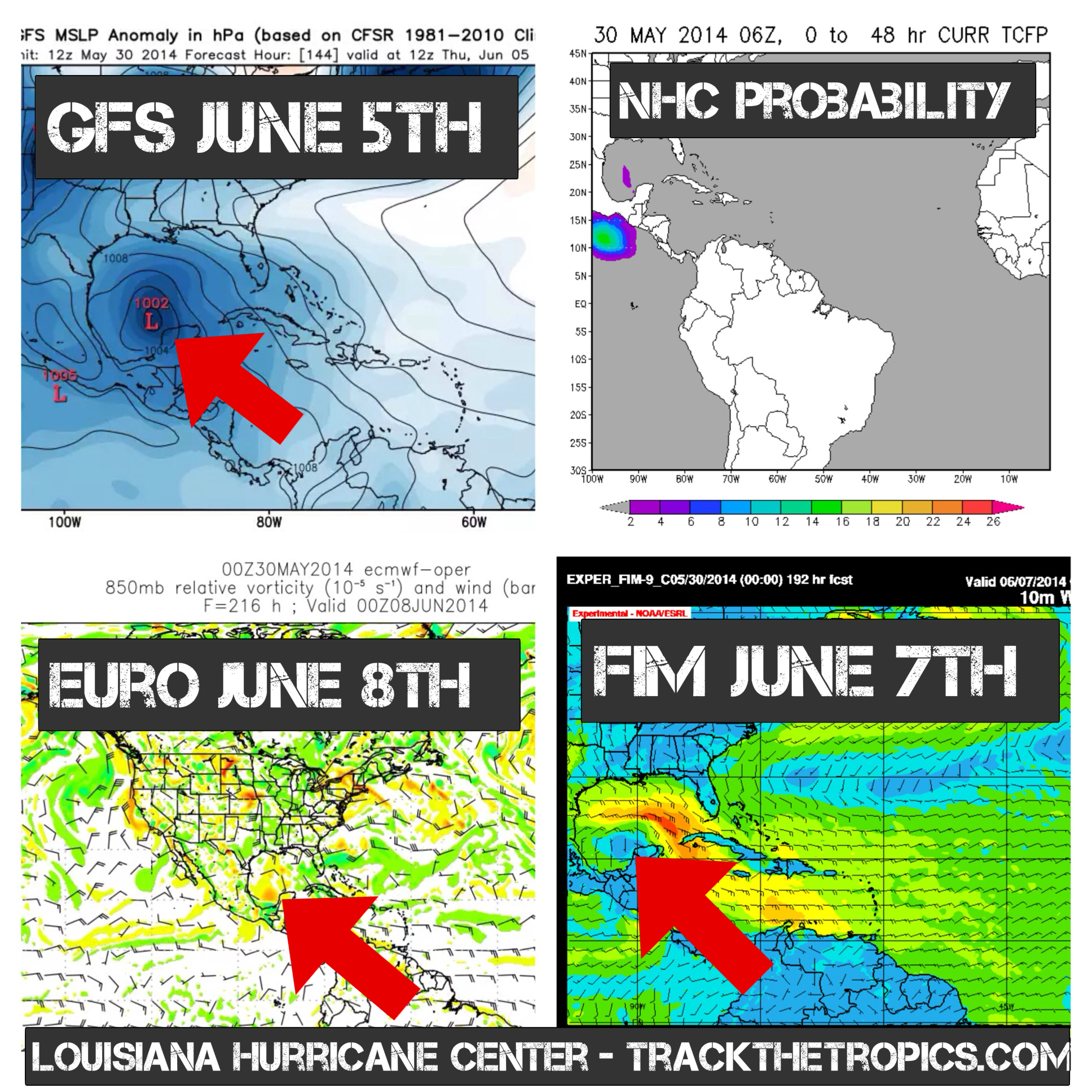
***MODEL WATCH*** Good afternoon y'all!! For the past couple weeks I have been talking about a possible storm in the Gulf at the beginning of June to start the 2014 Hurricane Season and models still continue to show this possibility...
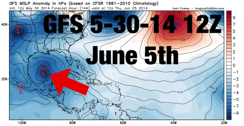
Here is the latest GFS that just ran today 5-30-14 12Z showing a possible Tropical Storm in the Gulf June 5th...
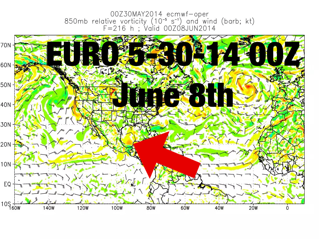
Here is the latest EURO showing possible development as well around June 8th...
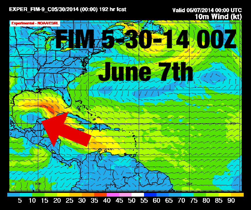
Latest FIM showing development around June 7th...
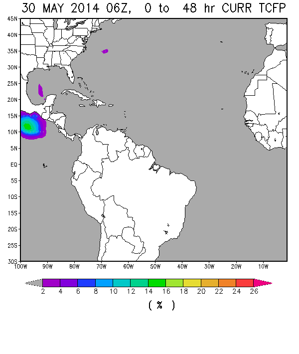
Also the latest NHC Tropical Formation Probability today has highlighted the area in the southern Gulf for potential development... we could see a possible investigation area by the NHC next week.
The CMC global model is on and off with development as well. With all 4 global models showing potential this is definitely something we need to start monitoring closely! I will continue to be on top of this possible development and let everyone know the latest! Good thing right now is that if something were to form shear in the Gulf is currently high and would inhibit any real strong storm from developing. If shear stays strong I see only a possible rain maker to Tropical Storm at the most. Things change daily in the Tropics though so keep a close eye on my future posts... stay tuned! One thing is for certain someone along the Gulf coast will be getting a lot of Tropical moisture coming their way!
--Chad TrackTheTropics.com
Tagged Development, Hurricane, Invest, LHC, Model Watch, NHC, Season, Tropical, Tropics

 DONATE