
![[Map of 1950-2017 CONUS Hurricane Strikes]](http://www.nhc.noaa.gov/climo/images/conus_strikes.jpg)


NHC Important Links: NHC Discussion / Public Advisory / Forecast Advisory / Wind Probs / Graphics / Storm Archive
Storm Tracking Important Links: Wind Analysis / Coastal Inundation Info / Tide Information / Surge Map / Surge Potential / Coastal Risk Map / Microwave Imagery / Advanced Dvorak ADT / GOES16 Satellite Storm Page / FSU Track Probability / NOAA Tracker / Albany Tracker / Navy NRL Page / HFIP Products / Tropical Atlantic Storm Page / NCAR Guidance Page / CyclonicWX Tracker / CIMSS Tracker / Tropical Tidbits Storm Page /UWM Tracker / SFWMD Models
Projected Path with Watches and Warnings


Most Likely Arrival Time of Tropical Storm Force Winds
 Most Reasonable Arrival Time of Tropical Storm Force Winds
 Hurricane Force Wind Probabilities
 Tropical Storm Force Wind Probabilities

Most Reasonable Arrival Time of Tropical Storm Force Winds
Hurricane Force Wind Probabilities
Tropical Storm Force Wind Probabilities


Surface Wind Field
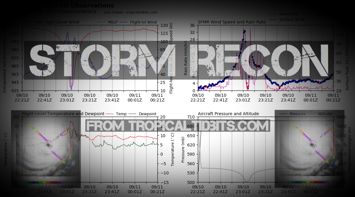
 Cumulative Wind History

 Cumulative Wind History
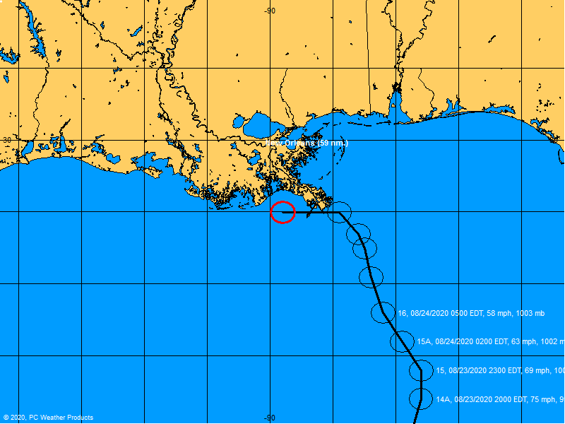
Windfield
Microwave Imagery
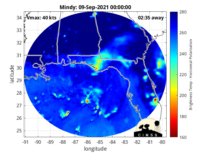
Microwave Imagery
Top Analog Tracks

WeatherNerds.org Floaters
Other Floater Sites:
TropicalTidbits - NRL Floaters - CyclonicWx - RAMMB Sat - RAMMB Model Data - RAMMB Wind Products

|

|

|

|
TropicalTidbits - NRL Floaters - CyclonicWx - RAMMB Sat - RAMMB Model Data - RAMMB Wind Products
Intensity Forecasts
 Model Tracks

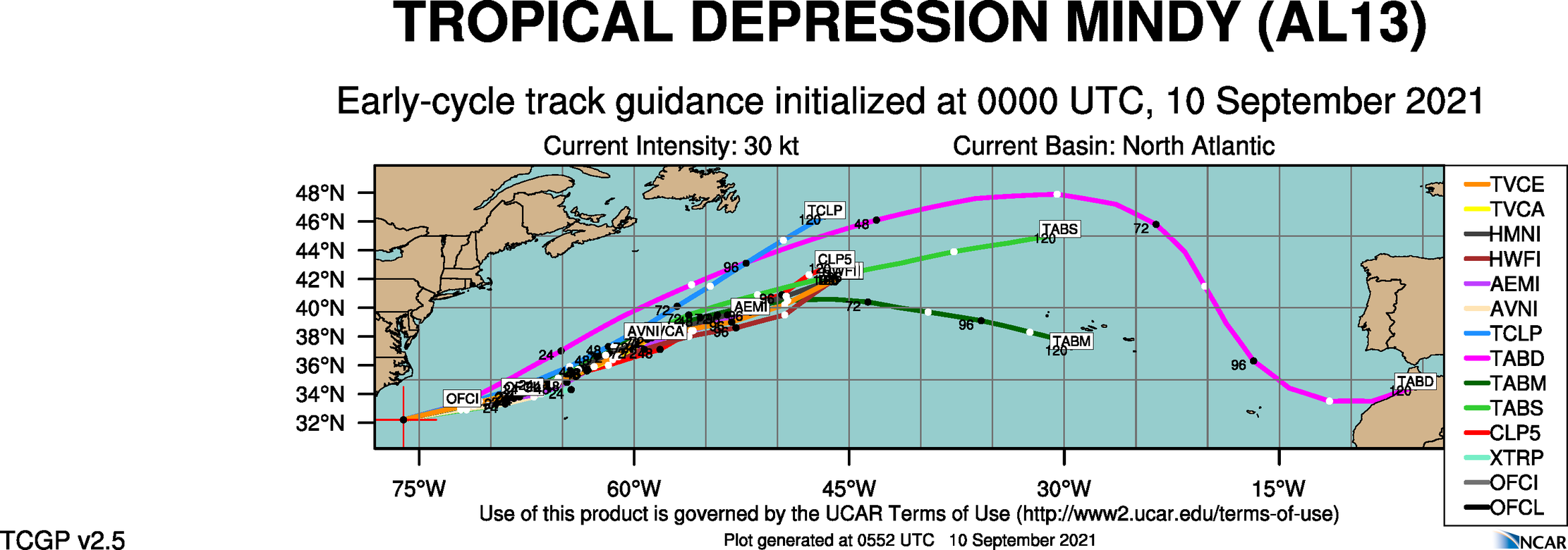

 GFS / Canadian Ensemble Tracks

EURO Ensemble Tracks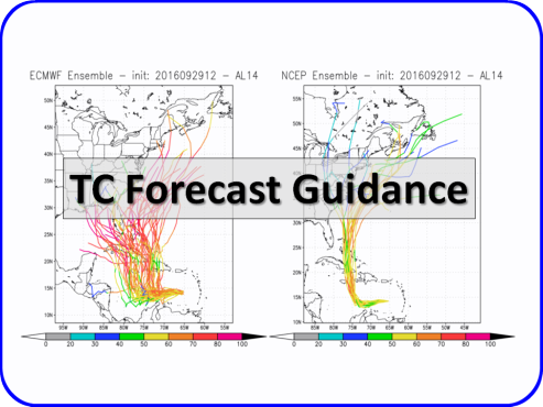
EPS Ensemble Tracks
Model Tracks
GFS / Canadian Ensemble Tracks
EURO Ensemble Tracks
EPS Ensemble Tracks
- Sat, 12 Oct 2024 14:40:57 +0000: Atlantic Remnants Of Leslie Advisory Number 41 - Atlantic Remnants Of Leslie Advisory Number 41
000
WTNT33 KNHC 121440
TCPAT3
BULLETIN
Remnants Of Leslie Advisory Number 41
NWS National Hurricane Center Miami FL AL132024
300 PM GMT Sat Oct 12 2024
...LESLIE DEGENERATES INTO A TROUGH...
...THIS IS THE LAST NHC ADVISORY...
SUMMARY OF 300 PM GMT...1500 UTC...INFORMATION
----------------------------------------------
LOCATION...33.3N 43.4W
ABOUT 975 MI...1570 KM WSW OF THE AZORES
MAXIMUM SUSTAINED WINDS...50 MPH...85 KM/H
PRESENT MOVEMENT...NE OR 50 DEGREES AT 31 MPH...50 KM/H
MINIMUM CENTRAL PRESSURE...1000 MB...29.53 INCHES
WATCHES AND WARNINGS
--------------------
There are no coastal watches or warnings in effect.
DISCUSSION AND OUTLOOK
----------------------
At 300 PM GMT (1500 UTC), the remnants of Leslie were located near
latitude 33.3 North, longitude 43.4 West. The remnants are moving
quickly toward the northeast near 31 mph (50 km/h). A gradual turn
toward the east at a fast forward speed is expected starting
tonight, with a continued eastward motion expected into early next
week. The remnants of Leslie are expected to move over or very near
the Azores Sunday and early Monday.
Recent satellite-derived wind data indicate that Leslie has
degenerated into a trough, but maximum sustained winds remain near
50 mph (85 km/h) with higher gusts. The remnants of Leslie are
expected to gradually weaken during the next couple of days.
Tropical-storm-force winds extend outward up to 140 miles (220 km)
from the center.
The estimated minimum central pressure is 1000 mb (29.53 inches).
HAZARDS AFFECTING LAND
----------------------
None.
NEXT ADVISORY
-------------
This is the last public advisory issued by the National Hurricane
Center on this system. Additional information on this system can be
found in High Seas Forecasts issued by the National Weather Service,
under AWIPS header NFDHSFAT1, WMO header FZNT01 KWBC, and online at
ocean.weather.gov/shtml/NFDHSFAT1.php
$$
Forecaster D. Zelinsky
- Sat, 12 Oct 2024 14:39:56 +0000: Atlantic Remnants of LESLIE Forecast/Advisory Numb... - Atlantic Remnants of LESLIE Forecast/Advisory Number 41 NWS NATIONAL Hurricane CENTER MIAMI FL AL132024 1500 UTC SAT OCT 12 2024 REMNANTS OF CENTER LOCATED NEAR 33.3N 43.4W AT 12/1500Z POSITION ACCURATE WITHIN 30 NM PRESENT MOVEMENT TOWARD THE NORTHEAST OR 50 DEGREES AT 27 KT ESTIMATED MINIMUM CENTRAL PRESSURE 1000 MB MAX SUSTAINED WINDS 45 KT WITH GUSTS TO 55 KT. 34 KT....... 80NE 120SE 60SW 0NW. 12 FT SEAS.. 90NE 210SE 210SW 90NW. WINDS AND SEAS VARY GREATLY IN EACH QUADRANT. RADII IN NAUTICAL MILES ARE THE LARGEST RADII EXPECTED ANYWHERE IN THAT QUADRANT. REPEAT...CENTER LOCATED NEAR 33.3N 43.4W AT 12/1500Z AT 12/1200Z CENTER WAS LOCATED NEAR 32.4N 44.9W FORECAST VALID 13/0000Z...DISSIPATED REQUEST FOR 3 HOURLY SHIP REPORTS WITHIN 300 MILES OF 33.3N 43.4W THIS IS THE LAST FORECAST/Advisory ISSUED BY THE NATIONAL HURRICANE CENTER ON THIS SYSTEM. ADDITIONAL INFORMATION ON THIS SYSTEM CAN BE FOUND IN HIGH SEAS FORECASTS ISSUED BY THE NATIONAL WEATHER SERVICE...UNDER AWIPS HEADER NFDHSFAT1 AND WMO HEADER FZNT01 KWBC. $$ FORECASTER D. ZELINSKY
000
WTNT23 KNHC 121439
TCMAT3
REMNANTS OF LESLIE FORECAST/ADVISORY NUMBER 41
NWS NATIONAL HURRICANE CENTER MIAMI FL AL132024
1500 UTC SAT OCT 12 2024
REMNANTS OF CENTER LOCATED NEAR 33.3N 43.4W AT 12/1500Z
POSITION ACCURATE WITHIN 30 NM
PRESENT MOVEMENT TOWARD THE NORTHEAST OR 50 DEGREES AT 27 KT
ESTIMATED MINIMUM CENTRAL PRESSURE 1000 MB
MAX SUSTAINED WINDS 45 KT WITH GUSTS TO 55 KT.
34 KT....... 80NE 120SE 60SW 0NW.
12 FT SEAS.. 90NE 210SE 210SW 90NW.
WINDS AND SEAS VARY GREATLY IN EACH QUADRANT. RADII IN NAUTICAL
MILES ARE THE LARGEST RADII EXPECTED ANYWHERE IN THAT QUADRANT.
REPEAT...CENTER LOCATED NEAR 33.3N 43.4W AT 12/1500Z
AT 12/1200Z CENTER WAS LOCATED NEAR 32.4N 44.9W
FORECAST VALID 13/0000Z...DISSIPATED
REQUEST FOR 3 HOURLY SHIP REPORTS WITHIN 300 MILES OF 33.3N 43.4W
THIS IS THE LAST FORECAST/ADVISORY ISSUED BY THE NATIONAL HURRICANE
CENTER ON THIS SYSTEM. ADDITIONAL INFORMATION ON THIS SYSTEM CAN BE
FOUND IN HIGH SEAS FORECASTS ISSUED BY THE NATIONAL WEATHER
SERVICE...UNDER AWIPS HEADER NFDHSFAT1 AND WMO HEADER FZNT01 KWBC.
$$
FORECASTER D. ZELINSKY
- Sat, 12 Oct 2024 14:42:27 +0000: Atlantic Remnants Of Leslie Discussion Number 41 - Atlantic Remnants Of Leslie Discussion Number 41
000
WTNT43 KNHC 121442
TCDAT3
Remnants Of Leslie Discussion Number 41
NWS National Hurricane Center Miami FL AL132024
300 PM GMT Sat Oct 12 2024
ASCAT-B data valid near 1300 UTC indicated that Leslie's fast
forward motion has caused it to open into a trough. Therefore, this
will be the last NHC advisory on Leslie. The ASCAT data indicated
that winds of 40-45 kt are still present on the east side of
Leslie's remnants, where it continues to produce limited deep
convection.
A mid-latitude frontal system is nearing the remnants of Leslie, and
the two systems are expected to merge within the next 12 h or so,
marking Leslie's full transition to a post-tropical cyclone. It is
possible that Leslie will redevelop a closed circulation as a
non-tropical low at that point. The cyclone is expected to turn
eastward on Sunday, bringing it very near or over the Azores late
Sunday and through early Monday. By Monday afternoon, Leslie's
center is expected to become poorly defined again as it interacts
with another weaker mid-latitude cyclone to the east of the Azores.
Additional information on this system can be found in High Seas
Forecasts issued by the National Weather Service, under AWIPS header
NFDHSFAT1, WMO header FZNT01 KWBC, and online at
ocean.weather.gov/shtml/NFDHSFAT1.php
FORECAST POSITIONS AND MAX WINDS
INIT 12/1500Z 33.3N 43.4W 45 KT 50 MPH...REMNANTS OF LESLIE
12H 13/0000Z...DISSIPATED
$$
Forecaster D. Zelinsky
2 Day Tropical Weather Outlook
5 Day Tropical Weather Outlook