2025 Hurricane Season – Track The Tropics – Spaghetti Models

Track The Tropics
SUPPORT TRACK THE TROPICS Over the last decade plus if you appreciate the information and tracking I provide during the season along with this website which donations help keep it running please consider a one time... recurring or yearly donation if you are able to help me out...

Venmo: @TrackTheTropicsLouisiana
Website: TrackTheTropics.com/DONATE
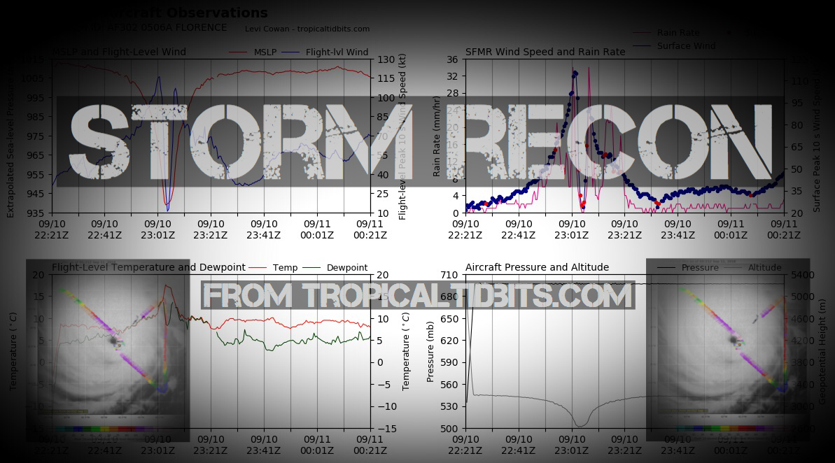
Track The Tropics is the #1 source to track the tropics 24/7! Since 2013 the main goal of the site is to bring all of the important links and graphics to ONE PLACE so you can keep up to date on any threats to land during the Atlantic Hurricane Season! Hurricane Season 2025 in the Atlantic starts on June 1st and ends on November 30th. Do you love Spaghetti Models? Well you've come to the right place!! Remember when you're preparing for a storm: Run from the water; hide from the wind!

Storm Recon

Storm Recon

Latest Posts on the LHC Blog

Saffir-Simpson Hurricane Scale
Category Wind Speed (mph) Storm Surge (ft)
5 ≥157 >18
4 130–156 13–18
3 111–129 9–12
2 96–110 6–8
1 74–95 4–5
Additional Classifications
Tropical Storm 39–73 0–3
Tropical Depression 0–38 0
The Saffir-Simpson Hurricane Scale is a classification used for most Western Hemisphere tropical cyclones that exceed the intensities of "tropical depressions" and "tropical storms", and thereby become hurricanes. Source: Intellicast

Hurricane Season 101

The official Atlantic Basin Hurricane Season runs from June 1st to November 30th. A tropical cyclone is a warm-core, low pressure system without any “front” attached. It develops over tropical or subtropical waters, and has an organized circulation. Depending upon location, tropical cyclones have different names around the world. The Tropical Cyclones we track in the Atlantic basin are called Tropical Depressions, Tropical Storms and Hurricanes! Atlantic Basin Tropical Cyclones are classified as follows: Tropical Depression: Organized system of clouds and thunderstorms with defined surface circulation and max sustained winds of 38 mph or less. Tropical Storm: Organized system of strong thunderstorms with a defined surface circulation and maximum sustained winds of 39-73 mph. Hurricane: Intense tropical weather system of strong thunderstorms with a well-defined surface circulation. A Hurricane has max sustained winds of 74 mph or higher!

The difference between Tropical Storm and Hurricane Watches, Warnings, Advisories and Outlooks

Warnings: Listen closely to instructions from local officials on TV, radio, cell phones or other computers for instructions from local officials. Evacuate immediately if told to do so. Please note that hurricane and tropical storm watches and warnings for winds on land as well as storm surge watches and warnings can be issued for storms that the NWS believes will become tropical cyclones but have not yet attained all of the characteristics of a tropical cyclone (i.e., a closed low-level circulation, sustained thunderstorm activity, etc.). In these cases, the forecast conditions on land warrant alerting the public. These storms are referred to as “potential tropical cyclones” by the NWS. Hurricane, tropical storm, and storm surge watches and warnings can also be issued for storms that have lost some or all of their tropical cyclone characteristics, but continue to produce dangerous conditions. These storms are called “post-tropical cyclones” by the NWS.

Watches: Listen closely to instructions from local officials on TV, radio, cell phones or other computers for instructions from local officials. Evacuate if told to do so. Advisories: Outlooks: Be sure to read up on tons of more information on Hurricane knowledge, preparedness, statistics and history under the menu on the left hand side of the page!

CONUS Hurricane Strikes

1950-2017
[Map of 1950-2017 CONUS Hurricane Strikes]

Total Hurricane Strikes 1900-2010 Total Hurricane Strikes 1900-2010

Total MAJOR Hurricane Strikes 1900-2010 Total Major Hurricane Strikes 1900-2010

Western Gulf Hurricane Strikes Western Gulf Hurricane Strikes

Western Gulf MAJOR Hurricane Strikes Western Gulf Major Hurricane Strikes

Eastern Gulf Hurricane Strikes Eastern Gulf Hurricane Strikes

Eastern Gulf MAJOR Hurricane Strikes Eastern Gulf Major Hurricane Strikes

SE Coast Hurricane Strikes SE Coast Hurricane Strikes

SE Coast MAJOR Hurricane Strikes SE Coast Major Hurricane Strikes

NE Coast Hurricane Strikes NE Coast Hurricane Strikes

NE Coast MAJOR Hurricane Strikes NE Coast Major Hurricane Strikes

Investigation (Invest) Area 99L – 2024 Hurricane Season

Share this page
Invest 99L NOAA Floater Invest 99L Floater
Invest 99L WeatherNerds.org Floaters
Invest 99L Model Tracks Invest 99L Model Tracks Invest 99L Model Tracks
Gulf Satellite Loops Atlantic Sat
Atlantic Sat
Invest 99L Intensity Forecasts Invest 99L Intensity Forecasts
Invest 99L Intensity Forecasts
Invest 99L EURO Ensemble Tracks EURO/GFS Ensembles from WeatherNerds
Invest 99L Best Track Invest 99L Best Track
Invest 99L GFS Ensemble Tracks EURO/GFS Ensembles from WeatherNerds
Average Days For System To Reach U.S.Average Days For System To Reach U.S.
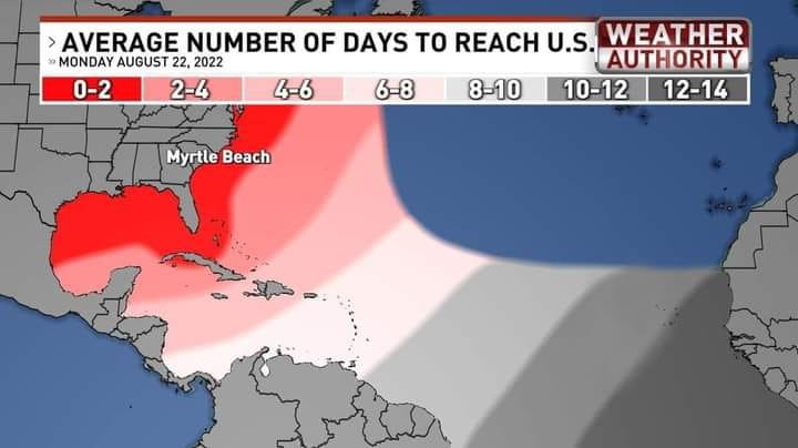
2 Day Tropical Weather OutlookAtlantic 2 Day GTWO graphic
7 Day Tropical Weather OutlookAtlantic 7 Day GTWO graphic
Share this page