
![[Map of 1950-2017 CONUS Hurricane Strikes]](http://www.nhc.noaa.gov/climo/images/conus_strikes.jpg)


NHC Important Links: NHC Discussion / Public Advisory / Forecast Advisory / Wind Probs / Graphics / Storm Archive
Important LOCAL Links: NWS Winds/Gusts/Waves Map / Current Power Outages / SPC Watches and Warnings
Storm Tracking Important Links: Wind Analysis / Coastal Inundation Info / Tide Information / Surge Map / Surge Potential / Coastal Risk Map / Microwave Imagery / Advanced Dvorak ADT / GOES16 Satellite Storm Page / FSU Track Probability / NOAA Tracker / Albany Tracker / Navy NRL Page / HFIP Products / Tropical Atlantic Storm Page / NCAR Guidance Page / CyclonicWX Tracker / CIMSS Tracker / Tropical Tidbits Storm Page /UWM Tracker / SFWMD Models
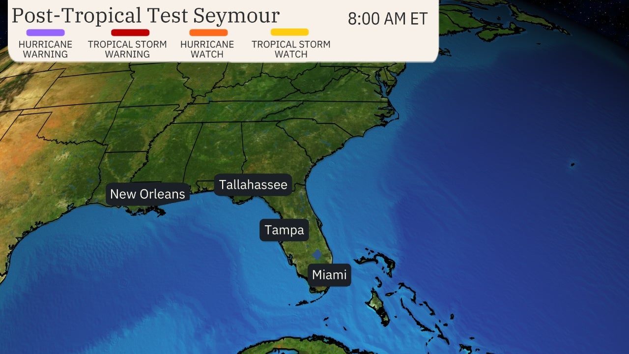
Projected Path with Watches and Warnings

Zoomed In Watches and Warnings
Additional Projected Path Swath

Zoomed In Watches and Warnings
Additional Projected Path Swath

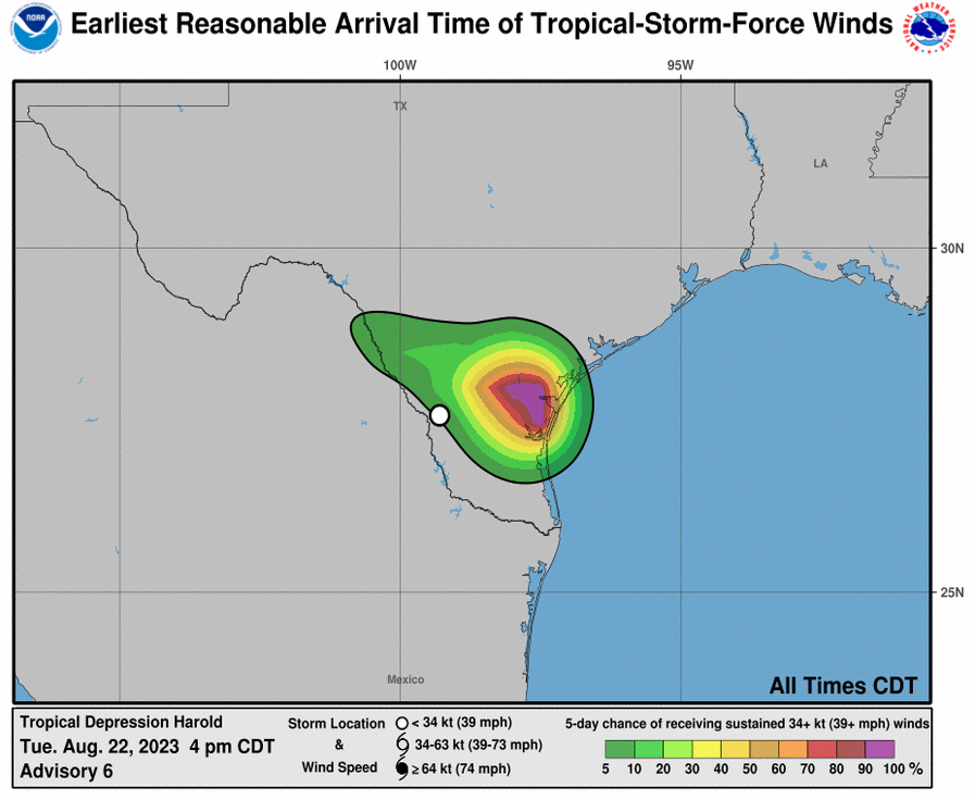
Most Likely Arrival Time of Tropical Storm Force Winds
 Most Reasonable Arrival Time of Tropical Storm Force Winds
 Hurricane Force Wind Probabilities
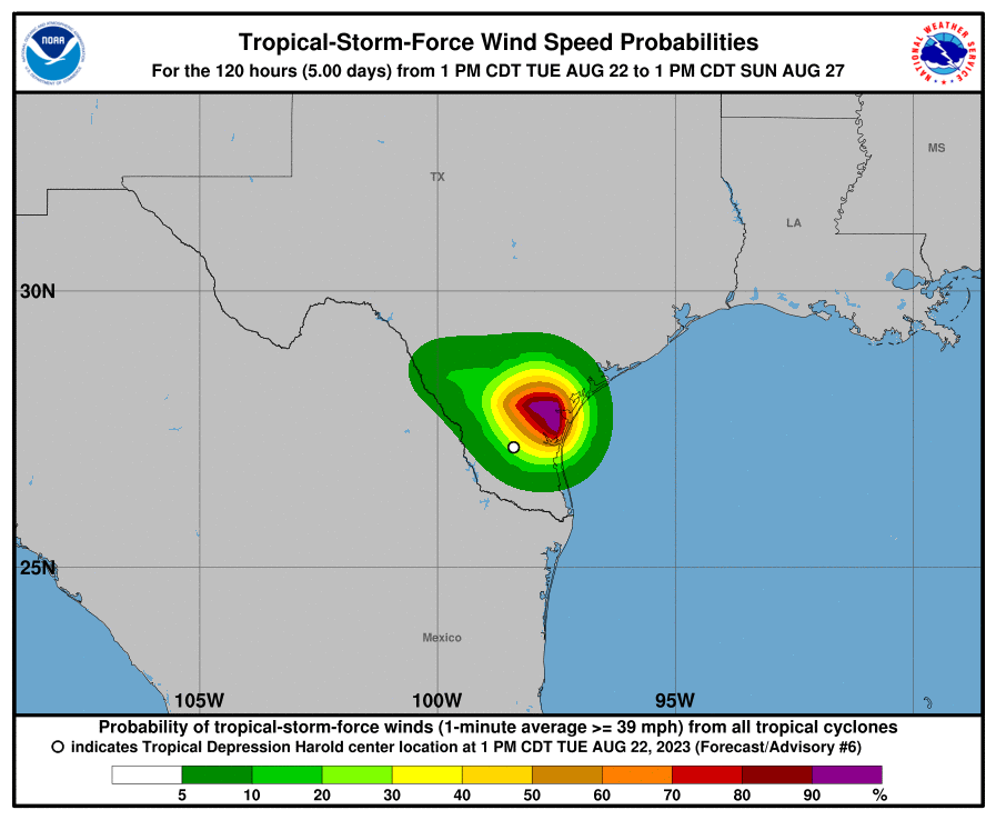
 Tropical Storm Force Wind Probabilities
 Most Reasonable Arrival Time of Tropical Storm Force Winds
Hurricane Force Wind Probabilities
Tropical Storm Force Wind Probabilities
Most Reasonable Arrival Time of Tropical Storm Force Winds
Hurricane Force Wind Probabilities
Tropical Storm Force Wind Probabilities
Surface Wind Field
 Cumulative Wind History

Cumulative Wind History
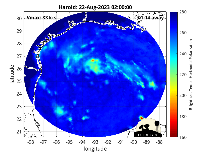
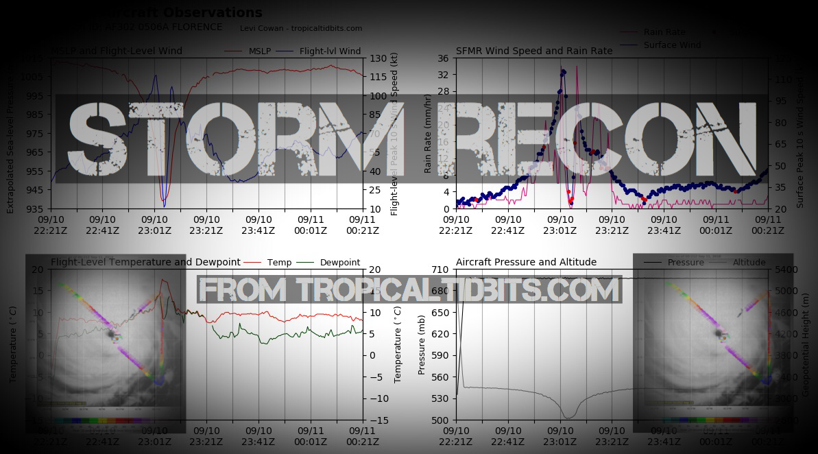
Microwave Imagery


Average Days For System To Reach U.S.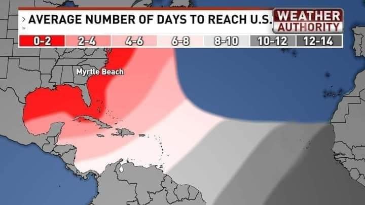
Peak Storm Surge Forecast

Potential Storm Surge Flooding Map (Inundation)
Additional Potential Storm Surge Map
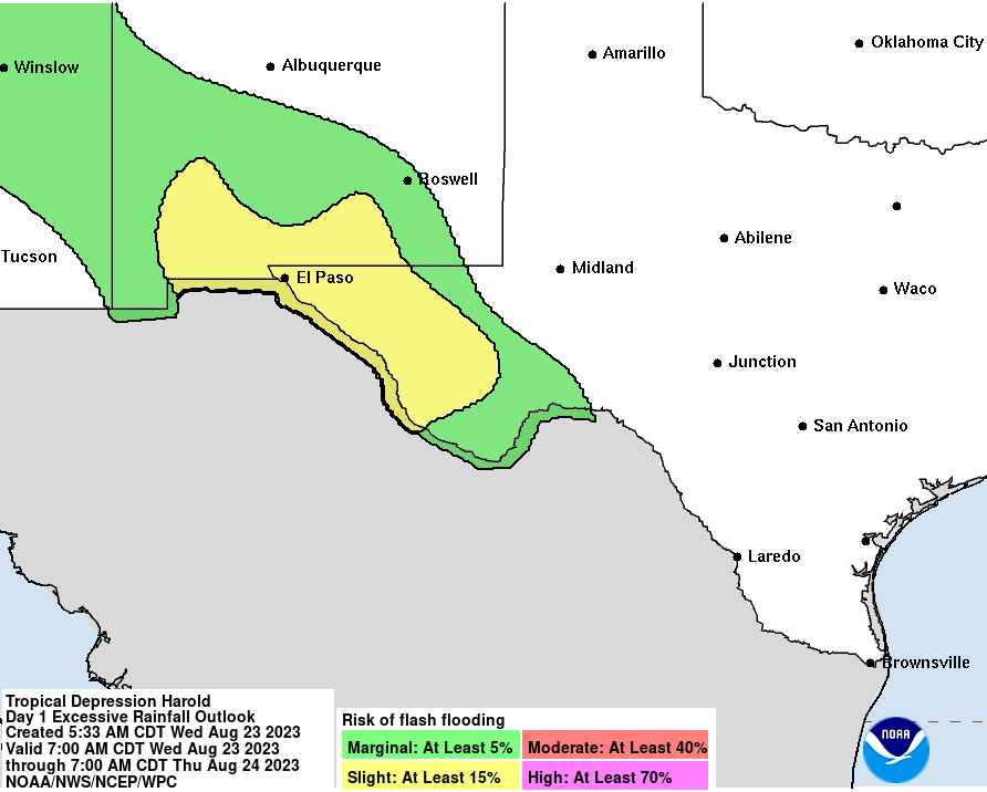
Flash Flood Risk
Rainfall Forecast

5 Day WPC Rainfall Forecast

24 hour - 7 Day
Potential Storm Surge Flooding Map (Inundation)
Additional Potential Storm Surge Map
Flash Flood Risk
Rainfall Forecast
5 Day WPC Rainfall Forecast
24 hour - 7 Day
Windshear Around Storm

Dry Air/ Water Vapor Around Storm

Dry Air/ Water Vapor Around Storm
LIVE Power Outage Map

SPC Watches and Warnings

SPC Watches and Warnings
Past Track History

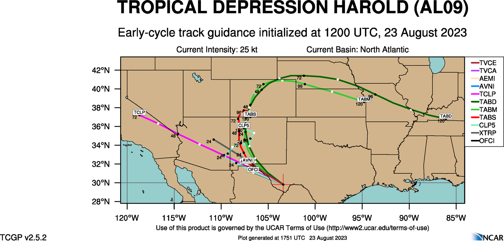
Top Analog Tracks

Key Messages

WeatherNerds.org Floaters
Other Floater Sites:
TropicalTidbits - NRL Floaters - CyclonicWx - RAMMB Sat - RAMMB Model Data - RAMMB Wind Products

|

|

|

|
TropicalTidbits - NRL Floaters - CyclonicWx - RAMMB Sat - RAMMB Model Data - RAMMB Wind Products

Intensity Forecasts
 Model Tracks


 GFS / Canadian Ensemble Tracks

EURO Ensemble Tracks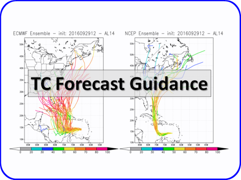
EPS Ensemble Tracks
Model Tracks
GFS / Canadian Ensemble Tracks
EURO Ensemble Tracks
EPS Ensemble Tracks
- Thu, 10 Oct 2024 20:34:36 +0000: Atlantic Post-Tropical Cyclone Milton Advisory Number 23 - Atlantic Post-Tropical Cyclone Milton Advisory Number 23
000
WTNT34 KNHC 102034
TCPAT4
BULLETIN
Post-Tropical Cyclone Milton Advisory Number 23
NWS National Hurricane Center Miami FL AL142024
500 PM EDT Thu Oct 10 2024
...STORM SURGE AND TROPICAL STORM WARNINGS FOR MILTON HAVE BEEN
DISCONTINUED...
...THIS IS THE LAST ADVISORY...
SUMMARY OF 500 PM EDT...2100 UTC...INFORMATION
----------------------------------------------
LOCATION...29.5N 76.3W
ABOUT 220 MI...355 KM NNE OF GREAT ABACO ISLAND
ABOUT 710 MI...1140 KM WSW OF BERMUDA
MAXIMUM SUSTAINED WINDS...70 MPH...110 KM/H
PRESENT MOVEMENT...E OR 80 DEGREES AT 21 MPH...33 KM/H
MINIMUM CENTRAL PRESSURE...983 MB...29.03 INCHES
WATCHES AND WARNINGS
--------------------
CHANGES WITH THIS ADVISORY:
All Storm Surge and Tropical Storm Warnings have been discontinued.
SUMMARY OF WATCHES AND WARNINGS IN EFFECT:
There are no coastal watches or warnings in effect.
DISCUSSION AND OUTLOOK
----------------------
At 500 PM EDT (2100 UTC), the center of Post-Tropical Cyclone Milton
was located near latitude 29.5 North, longitude 76.3 West. Milton
is moving toward the east near 21 mph (33 km/h), and this general
motion with an increase in forward speed is expected during the next
several days. On the forecast track, the center of the
post-tropical cyclone will pass to the south of Bermuda late Friday.
Maximum sustained winds have decreased to near 70 mph (110 km/h)
with higher gusts. Additional weakening is forecast during the
next several days.
Tropical-storm-force winds extend outward up to 310 miles (500 km)
from the center.
The estimated minimum central pressure is 983 mb (29.03 inches).
HAZARDS AFFECTING LAND
----------------------
Key Messages for Milton can be found in the Tropical Cyclone
Discussion under AWIPS header MIATCDAT4 and WMO header WTNT44 KNHC
and on the web at hurricanes.gov/text/MIATCDAT4.shtml
STORM SURGE: Coastal flooding is expected to continue along
portions of the southeastern U.S. coast through tonight. The water
could reach the following heights above ground somewhere in the
indicated areas...
Altamaha Sound, GA to Port Canaveral, FL...1-3 ft
St. Johns River...1-3 ft
For a complete depiction of areas at risk of storm surge
inundation, please see the National Weather Service Peak Storm
Surge Graphic, available at
hurricanes.gov/graphics_at4.shtml?peakSurge.
RAINFALL: Additional rainfall amounts up to an inch are possible
along the northeastern coast of Florida through this evening. In the
wake of heavy rainfall from Milton, the risk of considerable urban
flooding will linger through this evening across east central
Florida. Moderate to major river flooding is ongoing and forecast
throughout central Florida.
For a complete depiction of forecast rainfall associated with
Milton, please see the National Weather Service Storm Total Rainfall
Graphic, available at hurricanes.gov/graphics_at4.shtml?rainqpf and
the Flash Flood Risk graphic at
hurricanes.gov/graphics_at4.shtml?ero.
WIND: Gusty winds will likely continue along portions of the
southeastern U.S. coast through tonight.
SURF: Swells generated by Milton are expected to continue to
affect portions of the southeast U.S. and the Bahamas during the
next couple of days. These swells could cause life-threatening
surf and rip current conditions. Please consult products from your
local weather office.
NEXT ADVISORY
-------------
This is the last public advisory issued by the National Hurricane
Center on this system. Additional information on this system can be
found in High Seas Forecasts issued by the National Weather Service,
under AWIPS header NFDHSFAT1, WMO header FZNT01 KWBC, and online at
ocean.weather.gov/shtml/NFDHSFAT1.php
$$
Forecaster Berg
- Thu, 10 Oct 2024 20:34:36 +0000: Atlantic Post-Tropical Cyclone MILTON Forecast/Adv... - Atlantic Post-Tropical Cyclone MILTON Forecast/Advisory Number 23 NWS NATIONAL Hurricane CENTER MIAMI FL AL142024 2100 UTC THU OCT 10 2024 POST-TROPICAL Cyclone CENTER LOCATED NEAR 29.5N 76.3W AT 10/2100Z POSITION ACCURATE WITHIN 30 NM PRESENT MOVEMENT TOWARD THE EAST OR 80 DEGREES AT 18 KT ESTIMATED MINIMUM CENTRAL PRESSURE 983 MB MAX SUSTAINED WINDS 60 KT WITH GUSTS TO 75 KT. 50 KT.......100NE 100SE 90SW 110NW. 34 KT.......270NE 160SE 160SW 220NW. 12 FT SEAS..210NE 180SE 180SW 210NW. WINDS AND SEAS VARY GREATLY IN EACH QUADRANT. RADII IN NAUTICAL MILES ARE THE LARGEST RADII EXPECTED ANYWHERE IN THAT QUADRANT. REPEAT...CENTER LOCATED NEAR 29.5N 76.3W AT 10/2100Z AT 10/1800Z CENTER WAS LOCATED NEAR 29.5N 77.5W FORECAST VALID 11/0600Z 29.6N 72.8W...POST-TROP/EXTRATROP MAX WIND 60 KT...GUSTS 75 KT. 50 KT... 60NE 0SE 60SW 90NW. 34 KT...270NE 150SE 200SW 180NW. FORECAST VALID 11/1800Z 29.8N 67.4W...POST-TROP/EXTRATROP MAX WIND 50 KT...GUSTS 60 KT. 50 KT... 0NE 0SE 0SW 30NW. 34 KT...240NE 120SE 120SW 120NW. FORECAST VALID 12/0600Z 30.4N 62.3W...POST-TROP/EXTRATROP MAX WIND 40 KT...GUSTS 50 KT. 34 KT...220NE 0SE 90SW 120NW. FORECAST VALID 12/1800Z 31.0N 58.5W...POST-TROP/EXTRATROP MAX WIND 35 KT...GUSTS 45 KT. 34 KT... 0NE 0SE 0SW 120NW. FORECAST VALID 13/0600Z 32.1N 54.6W...POST-TROP/EXTRATROP MAX WIND 30 KT...GUSTS 40 KT. FORECAST VALID 13/1800Z 33.7N 49.6W...POST-TROP/EXTRATROP MAX WIND 25 KT...GUSTS 35 KT. EXTENDED OUTLOOK. NOTE...ERRORS FOR TRACK HAVE AVERAGED NEAR 125 NM ON DAY 4 AND 175 NM ON DAY 5...AND FOR INTENSITY NEAR 15 KT EACH DAY OUTLOOK VALID 14/1800Z...DISSIPATED REQUEST FOR 3 HOURLY SHIP REPORTS WITHIN 300 MILES OF 29.5N 76.3W THIS IS THE LAST FORECAST/Advisory ISSUED BY THE NATIONAL HURRICANE CENTER ON THIS SYSTEM. ADDITIONAL INFORMATION ON THIS SYSTEM CAN BE FOUND IN HIGH SEAS FORECASTS ISSUED BY THE NATIONAL WEATHER SERVICE...UNDER AWIPS HEADER NFDHSFAT1 AND WMO HEADER FZNT01 KWBC. $$ FORECASTER BERG
000
WTNT24 KNHC 102034
TCMAT4
POST-TROPICAL CYCLONE MILTON FORECAST/ADVISORY NUMBER 23
NWS NATIONAL HURRICANE CENTER MIAMI FL AL142024
2100 UTC THU OCT 10 2024
POST-TROPICAL CYCLONE CENTER LOCATED NEAR 29.5N 76.3W AT 10/2100Z
POSITION ACCURATE WITHIN 30 NM
PRESENT MOVEMENT TOWARD THE EAST OR 80 DEGREES AT 18 KT
ESTIMATED MINIMUM CENTRAL PRESSURE 983 MB
MAX SUSTAINED WINDS 60 KT WITH GUSTS TO 75 KT.
50 KT.......100NE 100SE 90SW 110NW.
34 KT.......270NE 160SE 160SW 220NW.
12 FT SEAS..210NE 180SE 180SW 210NW.
WINDS AND SEAS VARY GREATLY IN EACH QUADRANT. RADII IN NAUTICAL
MILES ARE THE LARGEST RADII EXPECTED ANYWHERE IN THAT QUADRANT.
REPEAT...CENTER LOCATED NEAR 29.5N 76.3W AT 10/2100Z
AT 10/1800Z CENTER WAS LOCATED NEAR 29.5N 77.5W
FORECAST VALID 11/0600Z 29.6N 72.8W...POST-TROP/EXTRATROP
MAX WIND 60 KT...GUSTS 75 KT.
50 KT... 60NE 0SE 60SW 90NW.
34 KT...270NE 150SE 200SW 180NW.
FORECAST VALID 11/1800Z 29.8N 67.4W...POST-TROP/EXTRATROP
MAX WIND 50 KT...GUSTS 60 KT.
50 KT... 0NE 0SE 0SW 30NW.
34 KT...240NE 120SE 120SW 120NW.
FORECAST VALID 12/0600Z 30.4N 62.3W...POST-TROP/EXTRATROP
MAX WIND 40 KT...GUSTS 50 KT.
34 KT...220NE 0SE 90SW 120NW.
FORECAST VALID 12/1800Z 31.0N 58.5W...POST-TROP/EXTRATROP
MAX WIND 35 KT...GUSTS 45 KT.
34 KT... 0NE 0SE 0SW 120NW.
FORECAST VALID 13/0600Z 32.1N 54.6W...POST-TROP/EXTRATROP
MAX WIND 30 KT...GUSTS 40 KT.
FORECAST VALID 13/1800Z 33.7N 49.6W...POST-TROP/EXTRATROP
MAX WIND 25 KT...GUSTS 35 KT.
EXTENDED OUTLOOK. NOTE...ERRORS FOR TRACK HAVE AVERAGED NEAR 125 NM
ON DAY 4 AND 175 NM ON DAY 5...AND FOR INTENSITY NEAR 15 KT EACH DAY
OUTLOOK VALID 14/1800Z...DISSIPATED
REQUEST FOR 3 HOURLY SHIP REPORTS WITHIN 300 MILES OF 29.5N 76.3W
THIS IS THE LAST FORECAST/ADVISORY ISSUED BY THE NATIONAL HURRICANE
CENTER ON THIS SYSTEM. ADDITIONAL INFORMATION ON THIS SYSTEM CAN BE
FOUND IN HIGH SEAS FORECASTS ISSUED BY THE NATIONAL WEATHER
SERVICE...UNDER AWIPS HEADER NFDHSFAT1 AND WMO HEADER FZNT01 KWBC.
$$
FORECASTER BERG
- Thu, 10 Oct 2024 20:35:39 +0000: Atlantic Post-Tropical Cyclone Milton Discussion Number 23 - Atlantic Post-Tropical Cyclone Milton Discussion Number 23
000
WTNT44 KNHC 102035
TCDAT4
Post-Tropical Cyclone Milton Discussion Number 23
NWS National Hurricane Center Miami FL AL142024
500 PM EDT Thu Oct 10 2024
Milton's satellite appearance has continued to take on an
extratropical appearance, and ASCAT data from a few hours ago
confirmed that the cyclone has become frontal. Based on that
information, Milton was declared post tropical in the 2 pm
intermediate advisory. The ASCAT passes showed maximum winds of
55-60 kt to the northwest of the center, so the initial intensity
is set to 60 kt.
Milton has turned eastward and sped up a bit (080/18 kt). A
general eastward motion with an increase in forward speed is
expected during the next several days, with the extratropical low
forecast to pass south of Bermuda in 24-36 hours. Global model
fields and intensity models indicate that the intensity should
gradually decrease during the next several days, and this is
reflected in the official forecast. Dissipation is shown by day 4,
although there is still some uncertainty if Milton will become
absorbed by the frontal zone before that time, or retain its
identity beyond 4 days.
Since all storm surge and tropical storm warnings have been
discontinued, this will be the last advisory on Milton. Additional
information on this system can be found in High Seas Forecasts
issued by the National Weather Service, under AWIPS header
NFDHSFAT1, WMO header FZNT01 KWBC, and online at
ocean.weather.gov/shtml/NFDHSFAT1.php
Key Messages:
1. Gusty winds and coastal flooding will gradually diminish along
portions of the southeastern U.S. coast through tonight.
2. In the wake of heavy rainfall from Milton, the risk of
considerable urban flooding will linger through this evening across
east central Florida. Moderate to major river flooding is ongoing
and forecast throughout central Florida.
3. In Florida, continue to use caution since deadly hazards remain,
including downed power lines and flooded areas. Ensure generators
are properly ventilated and placed outside at least 20 feet away
from doors, windows, and garages to avoid carbon monoxide poisoning.
If you are cleaning up storm damage, be careful when using
chainsaws and power tools, and drink plenty of water to avoid heat
exhaustion.
FORECAST POSITIONS AND MAX WINDS
INIT 10/2100Z 29.5N 76.3W 60 KT 70 MPH...POST-TROP/EXTRATROP
12H 11/0600Z 29.6N 72.8W 60 KT 70 MPH...POST-TROP/EXTRATROP
24H 11/1800Z 29.8N 67.4W 50 KT 60 MPH...POST-TROP/EXTRATROP
36H 12/0600Z 30.4N 62.3W 40 KT 45 MPH...POST-TROP/EXTRATROP
48H 12/1800Z 31.0N 58.5W 35 KT 40 MPH...POST-TROP/EXTRATROP
60H 13/0600Z 32.1N 54.6W 30 KT 35 MPH...POST-TROP/EXTRATROP
72H 13/1800Z 33.7N 49.6W 25 KT 30 MPH...POST-TROP/EXTRATROP
96H 14/1800Z...DISSIPATED
$$
Forecaster Berg
2 Day Tropical Weather Outlook
7 Day Tropical Weather Outlook