![[Map of 1950-2017 CONUS Hurricane Strikes]](http://www.nhc.noaa.gov/climo/images/conus_strikes.jpg)


NHC Important Links:
NHC Discussion / NHC Public Advisory / NHC Forecast / Wind Probs / Storm Archive
Important LOCAL Links:
NWS Lake Charles, Louisiana / NWS New Orleans/ Baton Rouge / Loops of Laura / Power Outages
Storm Tracking Important Links:
FSU Track Probability - NOAA Tracker - Albany Tracker - Navy NRL Page - HFIP Products - TropicalAtlantic Tracker - NCAR Guidance Page - CyclonicWX Tracker Products - CIMSS Tracker - TropicalTidbits Tracker - UWM Tracker - SFWMD Models
Projected Path with Watches and Warnings

Additional Projected Path Swath


Additional Projected Path Swath
Most Likely Arrival Time of Tropical Storm Force Winds
 Most Reasonable Arrival Time of Tropical Storm Force Winds
 Hurricane Force Wind Probabilities
 Tropical Storm Force Wind Probabilities

Most Reasonable Arrival Time of Tropical Storm Force Winds
Hurricane Force Wind Probabilities
Tropical Storm Force Wind Probabilities
Past Track History


Surface Wind Field
 Cumulative Wind History
 Top Analog Tracks

Cumulative Wind History
Top Analog Tracks
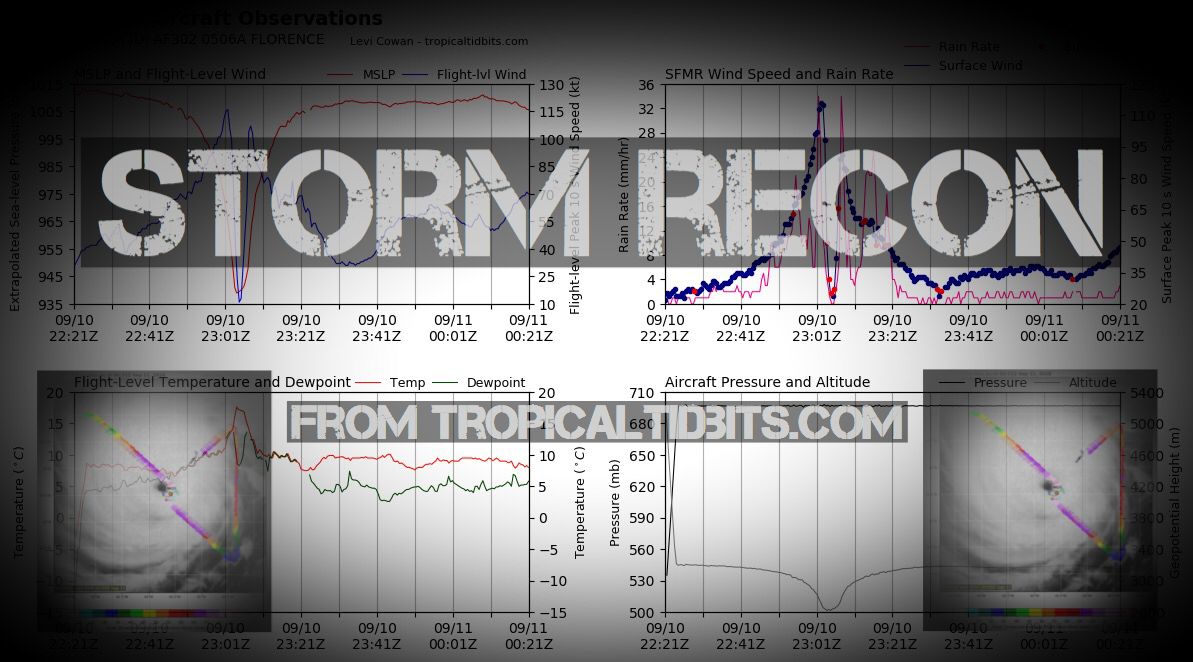
Windfield

Microwave Imagery
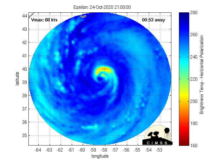
Microwave Imagery
Epsilon Key Messages


Intensity Forecasts
 Model Tracks


 GFS / Canadian Ensemble Tracks

EURO Ensemble Tracks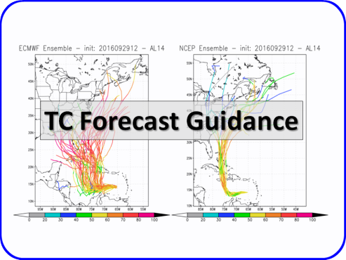
EPS Ensemble Tracks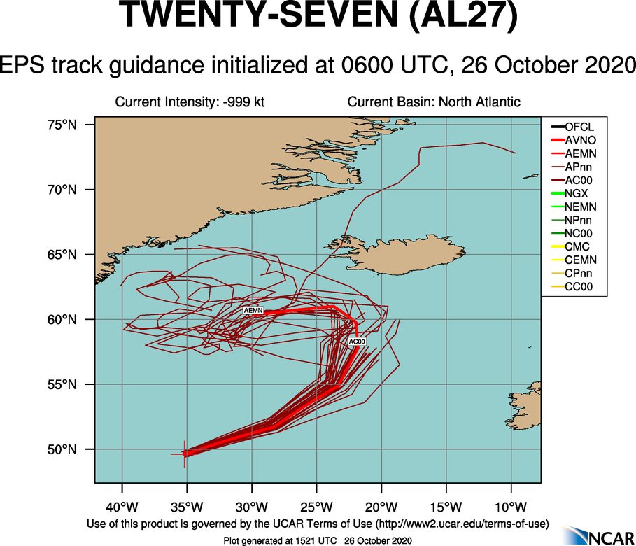
Model Tracks
GFS / Canadian Ensemble Tracks
EURO Ensemble Tracks
EPS Ensemble Tracks
- Sat, 18 Nov 2023 02:38:35 +0000: Atlantic Potential Tropical Cyclone Twenty-Two Advisory Number 6 - Atlantic Potential Tropical Cyclone Twenty-Two Advisory Number 6
000
WTNT32 KNHC 180238
TCPAT2
BULLETIN
Potential Tropical Cyclone Twenty-Two Advisory Number 6
NWS National Hurricane Center Miami FL AL222023
1000 PM EST Fri Nov 17 2023
...HEAVY RAINS LIKELY TO PRODUCE LIFE-THREATENING FLASH FLOODING AND
MUDSLIDES ACROSS SOUTHEASTERN CUBA AND HISPANIOLA THIS WEEKEND...
...THIS IS THE FINAL NHC ADVISORY AS ALL WATCHES HAVE BEEN
DISCONTINUED AND TROPICAL CYCLONE FORMATION IS NOT EXPECTED...
SUMMARY OF 1000 PM EST...0300 UTC...INFORMATION
-----------------------------------------------
LOCATION...20.0N 76.5W
ABOUT 140 MI...220 KM NE OF MONTEGO BAY JAMAICA
ABOUT 85 MI...135 KM W OF GUANTANAMO CUBA
MAXIMUM SUSTAINED WINDS...35 MPH...55 KM/H
PRESENT MOVEMENT...NE OR 45 DEGREES AT 22 MPH...35 KM/H
MINIMUM CENTRAL PRESSURE...1006 MB...29.71 INCHES
WATCHES AND WARNINGS
--------------------
CHANGES WITH THIS ADVISORY:
The Tropical Storm Watch for Haiti has been discontinued.
SUMMARY OF WATCHES AND WARNINGS IN EFFECT:
There are no coastal watches or warnings in effect.
For storm information specific to your area, please monitor products
issued by your national meteorological service.
DISCUSSION AND OUTLOOK
----------------------
At 1000 PM EST (0300 UTC), the disturbance was centered near
latitude 20.0 North, longitude 76.5 West. The system is moving
toward the northeast near 22 mph (35 km/h), and a faster
northeastward motion is expected overnight. On the forecast track,
the disturbance is expected to move across southeastern Cuba during
the next few hours.
Maximum sustained winds are near 35 mph (55 km/h) with higher gusts.
The disturbance appears unlikely to become a tropical cyclone before
it merges with a frontal system later this weekend.
* Formation chance through 48 hours...low...10 percent.
* Formation chance through 7 days...low...10 percent.
The estimated minimum central pressure is 1006 mb (29.71 inches).
HAZARDS AFFECTING LAND
----------------------
Key messages for Potential Tropical Cyclone Twenty-Two can be found
in the Tropical Cyclone Discussion under AWIPS header MIATCDAT2 and
WMO header WTNT42 KNHC, and on the web at
hurricanes.gov/text/MIATCDAT2.shtml
RAINFALL: This disturbance is expected to produce additional total
rainfall of 4 to 8 inches with maximum amounts of 14 inches across
portions of southeastern Cuba and southern Hispaniola through
Sunday. These rains are likely to produce flash flooding, along with
mudslides in areas of higher terrain.
The system is expected to produce an additional 2 to 4 inches of
rainfall across Jamaica, the southeastern Bahamas, as well as the
Turks and Caicos Islands. This rainfall may lead to flash flooding
in urban areas.
SURF: Swells generated by the disturbance are expected to affect
portions of Jamaica, Haiti, and southeastern Cuba through Saturday.
These swells are likely to cause life-threatening surf and rip
current conditions. Please consult products from your local weather
office.
NEXT ADVISORY
-------------
This is the last public advisory issued by the National Hurricane
Center on this system. Additional information on this system can be
found in High Seas Forecasts issued by the National Weather Service,
under AWIPS header NFDHSFAT1, WMO header FZNT01 KWBC, and online at
ocean.weather.gov/shtml/NFDHSFAT1.php
$$
Forecaster Reinhart
- Sat, 18 Nov 2023 02:37:04 +0000: Atlantic Potential Tropical Cyclone TWENTY-TWO For... - Atlantic Potential Tropical Cyclone TWENTY-TWO Forecast/Advisory Number 6 NWS NATIONAL Hurricane CENTER MIAMI FL AL222023 0300 UTC SAT NOV 18 2023 NOTICE... LAND-BASED TROPICAL Cyclone WATCHES AND WARNINGS ARE NO LONGER INCLUDED IN THE TROPICAL CYCLONE FORECAST/Advisory...(TCM). CURRENT LAND-BASED COASTAL WATCHES AND WARNINGS CAN BE FOUND IN THE MOST RECENTLY ISSUED TROPICAL CYCLONE PUBLIC ADVISORY...(TCP). POTENTIAL TROP CYCLONE CENTER LOCATED NEAR 20.0N 76.5W AT 18/0300Z POSITION ACCURATE WITHIN 60 NM PRESENT MOVEMENT TOWARD THE NORTHEAST OR 45 DEGREES AT 19 KT ESTIMATED MINIMUM CENTRAL PRESSURE 1006 MB MAX SUSTAINED WINDS 30 KT WITH GUSTS TO 40 KT. WINDS AND SEAS VARY GREATLY IN EACH QUADRANT. RADII IN NAUTICAL MILES ARE THE LARGEST RADII EXPECTED ANYWHERE IN THAT QUADRANT. REPEAT...CENTER LOCATED NEAR 20.0N 76.5W AT 18/0300Z AT 18/0000Z CENTER WAS LOCATED NEAR 19.3N 77.2W FORECAST VALID 18/1200Z...DISSIPATED REQUEST FOR 3 HOURLY SHIP REPORTS WITHIN 300 MILES OF 20.0N 76.5W THIS IS THE LAST FORECAST/ADVISORY ISSUED BY THE NATIONAL HURRICANE CENTER ON THIS SYSTEM. ADDITIONAL INFORMATION ON THIS SYSTEM CAN BE FOUND IN HIGH SEAS FORECASTS ISSUED BY THE NATIONAL WEATHER SERVICE...UNDER AWIPS HEADER NFDHSFAT1 AND WMO HEADER FZNT01 KWBC. $$ FORECASTER REINHART
000
WTNT22 KNHC 180236
TCMAT2
POTENTIAL TROPICAL CYCLONE TWENTY-TWO FORECAST/ADVISORY NUMBER 6
NWS NATIONAL HURRICANE CENTER MIAMI FL AL222023
0300 UTC SAT NOV 18 2023
NOTICE... LAND-BASED TROPICAL CYCLONE WATCHES AND WARNINGS ARE NO
LONGER INCLUDED IN THE TROPICAL CYCLONE FORECAST/ADVISORY...(TCM).
CURRENT LAND-BASED COASTAL WATCHES AND WARNINGS CAN BE FOUND IN THE
MOST RECENTLY ISSUED TROPICAL CYCLONE PUBLIC ADVISORY...(TCP).
POTENTIAL TROP CYCLONE CENTER LOCATED NEAR 20.0N 76.5W AT 18/0300Z
POSITION ACCURATE WITHIN 60 NM
PRESENT MOVEMENT TOWARD THE NORTHEAST OR 45 DEGREES AT 19 KT
ESTIMATED MINIMUM CENTRAL PRESSURE 1006 MB
MAX SUSTAINED WINDS 30 KT WITH GUSTS TO 40 KT.
WINDS AND SEAS VARY GREATLY IN EACH QUADRANT. RADII IN NAUTICAL
MILES ARE THE LARGEST RADII EXPECTED ANYWHERE IN THAT QUADRANT.
REPEAT...CENTER LOCATED NEAR 20.0N 76.5W AT 18/0300Z
AT 18/0000Z CENTER WAS LOCATED NEAR 19.3N 77.2W
FORECAST VALID 18/1200Z...DISSIPATED
REQUEST FOR 3 HOURLY SHIP REPORTS WITHIN 300 MILES OF 20.0N 76.5W
THIS IS THE LAST FORECAST/ADVISORY ISSUED BY THE NATIONAL HURRICANE
CENTER ON THIS SYSTEM. ADDITIONAL INFORMATION ON THIS SYSTEM CAN BE
FOUND IN HIGH SEAS FORECASTS ISSUED BY THE NATIONAL WEATHER
SERVICE...UNDER AWIPS HEADER NFDHSFAT1 AND WMO HEADER FZNT01 KWBC.
$$
FORECASTER REINHART
- Sat, 18 Nov 2023 02:39:35 +0000: Atlantic Potential Tropical Cyclone Twenty-Two Discussion Number 6 - Atlantic Potential Tropical Cyclone Twenty-Two Discussion Number 6
000
WTNT42 KNHC 180239
TCDAT2
Potential Tropical Cyclone Twenty-Two Discussion Number 6
NWS National Hurricane Center Miami FL AL222023
1000 PM EST Fri Nov 17 2023
The broad disturbance has failed to become better organized today.
The associated convection remains displaced well to the east of the
surface trough axis by strong southwesterly shear. The earlier
aircraft reconnaissance data showed the disturbance was only
producing peak winds of 25-30 kt. Given its lack of a well-defined
surface center, poor convective organization, and the continued
hostile environmental conditions it faces, this system is no longer
expected to become a tropical cyclone. Additionally, the risk of
sustained tropical-storm-force winds on land has greatly diminished,
and all tropical storm watches have been discontinued. Therefore,
this will be the final NHC advisory on this system.
The remnants of this disturbance are expected to accelerate
northeastward ahead of a shortwave trough and merge with a frontal
system over the southwestern Atlantic Ocean later this weekend.
Although tropical cyclone formation is not expected, there is high
confidence that heavy rainfall and flooding will remain a serious
threat across southeastern Cuba and Hispaniola through Sunday.
Additional rainfall amounts of 4 to 8 inches, with maximum amounts
of 14 inches, are expected across portions of these areas, which is
likely to produce life-threatening flash flooding and mudslides.
For storm information specific to your area, please monitor products
issued by your national meteorological service. Additional
information on this system can be found in High Seas Forecasts
issued by the National Weather Service, under AWIPS header
NFDHSFAT1, WMO header FZNT01 KWBC, and online at
ocean.weather.gov/shtml/NFDHSFAT1.php
KEY MESSAGES:
1. Heavy rains from this disturbance will impact portions of
southeastern Cuba and southern Hispaniola through Sunday. This
rainfall is likely to produce flash flooding, along with mudslides
in areas of higher terrain. Lighter amounts across Jamaica, the
southeastern Bahamas, and the Turks and Caicos Islands may lead to
flash flooding in urban areas.
FORECAST POSITIONS AND MAX WINDS
INIT 18/0300Z 20.0N 76.5W 30 KT 35 MPH...INLAND
12H 18/1200Z...DISSIPATED
$$
Forecaster Reinhart
2 Day Tropical Weather Outlook
5 Day Tropical Weather Outlook
Facebook Comments