0 Active Threats To Track
SUPPORT TRACK THE TROPICS
Over the last decade plus if you appreciate the information and tracking I provide during the season along with this website which donations help keep it running please consider a one time... recurring or yearly donation if you are able to help me out...
Venmo: @TrackTheTropicsLouisiana
Website: TrackTheTropics.com/DONATE
Venmo: @TrackTheTropicsLouisiana
Website: TrackTheTropics.com/DONATE
Current Tropics Activity (hidden template)
| U.S. THREAT | Active Storm |
| ALERT | Active Storm |
| ALERT | Active Invest 90L |
| WATCHING | 1 Area Of Interest |
Track The Tropics is the #1 source to track the tropics 24/7! Since 2013 the main goal of the site is to bring all of the important links and graphics to ONE PLACE so you can keep up to date on any threats to land during the Atlantic Hurricane Season! Hurricane Season 2025 in the Atlantic starts on June 1st and ends on November 30th. Do you love Spaghetti Models? Well you've come to the right place!! Remember when you're preparing for a storm: Run from the water; hide from the wind!
Tropical Atlantic Weather Resources
- NOAA National Hurricane Center
- International Meteorology Database
- FSU Tropical Cyclone Track Probabilities
- Brian McNoldy Atlantic Headquarters
- Brian McNoldy Tropical Satellite Sectors
- Brian McNoldy Infrared Hovmoller
- Brian McNoldy Past TC Radar Loops
- Weather Nerds Models/ TC Guidance/ Sat
- Twister Data Model Guidance
- NOAA Tropical Cyclone Tracks
- Albany GFS/ EURO Models/ Ensembles
- Albany Tropical Cyclone Guidance
- Albany Tropical Atlantic Model Maps
- Pivotal Weather Model Guidance
- Weather Online Model Guidance
- UKMet Model Guidance/ Analysis/ Sat
- ECMWF (EURO) Model Guidance/ Analysis
- FSU Tropical Model Outputs
- FSU Tropical Cyclone Genesis
- Penn State Tropical E-Wall
- NOAA HFIP Ruc Models
- Navy NRL TC Page
- College of DuPage Model Guidance
- WXCharts Model Guidance
- NOAA NHC Analysis Tools
- NOAA NHC ATCF Directory
- NOAA NCEP/EMC Cyclogenesis Tracking
- NOAA NCEP/EMC HWRF Model
- NOAA HFIP Model Products
- University of Miami Ocean Heat Content
- COLA Max Potential Hurricane Intensity
- Colorado State RAMMB TC Tracking
- Colorado State RAMMB Tropical Floaters
- Colorado State RAMMB GOES-16 Viewer
- NOAA NESDIS GOES Satellite
- ASCAT Ocean Surface Winds METOP-A
- ASCAT Ocean Surface Winds METOP-B
- Michael Ventrice Waves / MJO Maps
- TropicalAtlantic.com Analysis / Recon
- NCAR/RAL Tropical Cyclone Guidance
- CyclonicWX Tropical Resources
Main Menu
- 2023 Atlantic Hurricane Season Main Page
- Official Atlantic Tracking Chart
- Support Track The Tropics!
- Tropical Weather Outlook
- Interactive Tracking Map
- Live Current and Future Winds
- Gulf / East Coast and Atlantic Satellite
- Africa / East Atlantic Satellite Loops
- Gulf of Mexico and East Coast Radar
- Current Tropical Surface Analysis Maps
- Future Tropical Surface Analysis Maps
- Sea Surface Temperatures (SSTs)
- Atlantic Wind Shear
- Current Wind Direction Steering
- Precipitation Totals Forecasts
- Saharan Air Layer (SAL) Tracking
- MJO Model Forecasts
- El Niño & La Niña Status and Forecasts
- Real Time Buoy and Oil Rig Data
- Real Time Storm Surge Maps and Info
- Hurricane Season News / Blog
- 2018 – 2023 Hurricane Season Names
- 2019 Hurricane Season Storms
- Important Weather Links
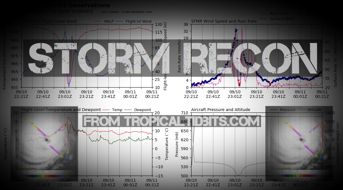
Storm Recon
Learn and Prepare for Hurricanes
Cyclone Archive Pages and Links
Latest Posts on the LHC Blog
Saffir-Simpson Hurricane Scale
| Category | Wind Speed (mph) | Storm Surge (ft) |
| 5 | ≥157 | >18 |
| 4 | 130–156 | 13–18 |
| 3 | 111–129 | 9–12 |
| 2 | 96–110 | 6–8 |
| 1 | 74–95 | 4–5 |
| Additional Classifications | ||
| Tropical Storm | 39–73 | 0–3 |
| Tropical Depression | 0–38 | 0 |
Hurricane Season 101
The official Atlantic Basin Hurricane Season runs from June 1st to November 30th. A tropical cyclone is a warm-core, low pressure system without any “front” attached. It develops over tropical or subtropical waters, and has an organized circulation. Depending upon location, tropical cyclones have different names around the world. The Tropical Cyclones we track in the Atlantic basin are called Tropical Depressions, Tropical Storms and Hurricanes! Atlantic Basin Tropical Cyclones are classified as follows: Tropical Depression: Organized system of clouds and thunderstorms with defined surface circulation and max sustained winds of 38 mph or less. Tropical Storm: Organized system of strong thunderstorms with a defined surface circulation and maximum sustained winds of 39-73 mph. Hurricane: Intense tropical weather system of strong thunderstorms with a well-defined surface circulation. A Hurricane has max sustained winds of 74 mph or higher!The difference between Tropical Storm and Hurricane Watches, Warnings, Advisories and Outlooks
Warnings: Listen closely to instructions from local officials on TV, radio, cell phones or other computers for instructions from local officials. Evacuate immediately if told to do so.- Storm Surge Warning: There is a danger of life-threatening inundation from rising water moving inland from the shoreline somewhere within the specified area. This is generally within 36 hours. If you are under a storm surge warning, check for evacuation orders from your local officials.
- Hurricane Warning: Hurricane conditions (sustained winds of 74 mph or greater) are expected somewhere within the specified area. NHC issues a hurricane warning 36 hours in advance of tropical storm-force winds to give you time to complete your preparations. All preparations should be complete. Evacuate immediately if so ordered.
- Tropical Storm Warning: Tropical storm conditions (sustained winds of 39 to 73 mph) are expected within your area within 36 hours.
- Extreme Wind Warning: Extreme sustained winds of a major hurricane (115 mph or greater), usually associated with the eyewall, are expected to begin within an hour. Take immediate shelter in the interior portion of a well-built structure.
Watches: Listen closely to instructions from local officials on TV, radio, cell phones or other computers for instructions from local officials. Evacuate if told to do so.
- Storm Surge Watch: Storm here is a possibility of life-threatening inundation from rising water moving inland from the shoreline somewhere within the specified area, generally within 48 hours. If you are under a storm surge watch, check for evacuation orders from your local officials.
- Hurricane Watch: Huriricane conditions (sustained winds of 74 mph or greater) are possible within your area. Because it may not be safe to prepare for a hurricane once winds reach tropical storm force, The NHC issues hurricane watches 48 hours before it anticipates tropical storm-force winds.
- Tropical Storm Watch: Tropical storm conditions (sustained winds of 39 to 73 mph) are possible within the specified area within 48 hours.
- Tropical Cyclone Public Advisory:The Tropical Cyclone Public Advisory contains a list of all current coastal watches and warnings associated with an ongoing or potential tropical cyclone, a post-tropical cyclone, or a subtropical cyclone. It also provides the cyclone position, maximum sustained winds, current motion, and a description of the hazards associated with the storm.
- Tropical Cyclone Track Forecast Cone:This graphic shows areas under tropical storm and hurricane watches and warnings, the current position of the center of the storm, and its predicted track. Forecast uncertainty is conveyed on the graphic by a “cone” (white and stippled areas) drawn such that the center of the storm will remain within the cone about 60 to 70 percent of the time. Remember, the effects of a tropical cyclone can span hundreds of miles. Areas well outside of the cone often experience hazards such as tornadoes or inland flooding from heavy rain.
- Tropical Weather Outlook:The Tropical Weather Outlook is a discussion of significant areas of disturbed weather and their potential for development during the next 5 days. The Outlook includes a categorical forecast of the probability of tropical cyclone formation during the first 48 hours and during the entire 5-day forecast period. You can also find graphical versions of the 2-day and 5-day Outlook here
TrackTheTropics Resource Links
- National Hurricane Center
- Tropical Tidbits
- CIMSS Tropical Group
- Tropical Atlantic
- NASA Earth
- Intellicast
- NOAA WPC
- UWM Hurricane Models
- South Florida Hurricane Models
- Accuweather
- Weather.com
- FSU TC Models
- NOAA TC Probability
- NCEP/EMC Cyclogenesis Tracking
- NOAA GOES East Imagery
- Unisys Hurricane Data
- PSU Tropical Group
- Weather Underground
- NOAA NESDIS
- NRL Tropical Cyclone Page
- Storm Surfing
- GMU WxMaps
CONUS Hurricane Strikes
![[Map of 1950-2017 CONUS Hurricane Strikes]](http://www.nhc.noaa.gov/climo/images/conus_strikes.jpg)
Total Hurricane Strikes 1900-2010

Total MAJOR Hurricane Strikes 1900-2010

Western Gulf Hurricane Strikes

Western Gulf MAJOR Hurricane Strikes

Eastern Gulf Hurricane Strikes

Eastern Gulf MAJOR Hurricane Strikes

SE Coast Hurricane Strikes

SE Coast MAJOR Hurricane Strikes

NE Coast Hurricane Strikes

NE Coast MAJOR Hurricane Strikes

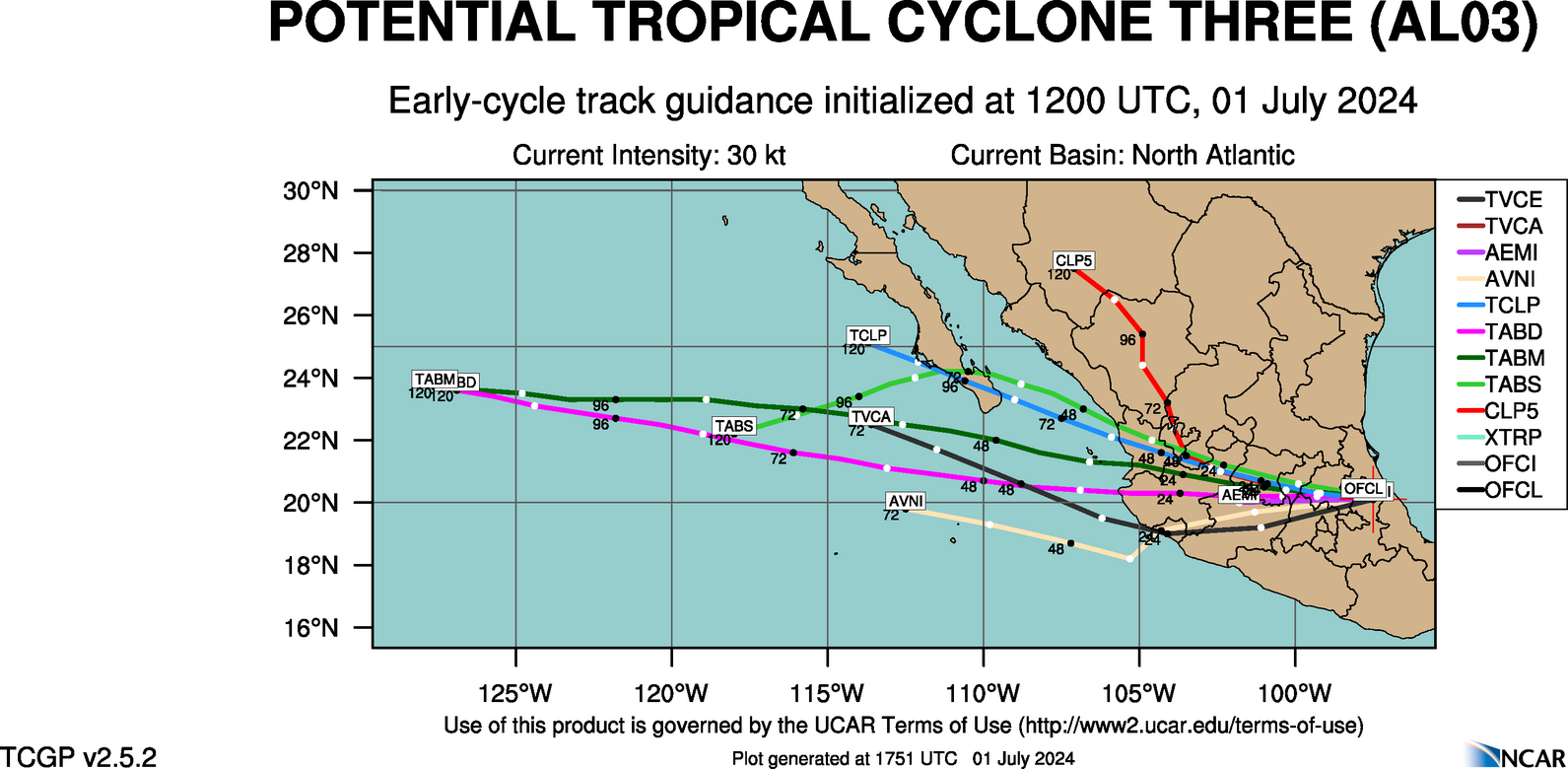
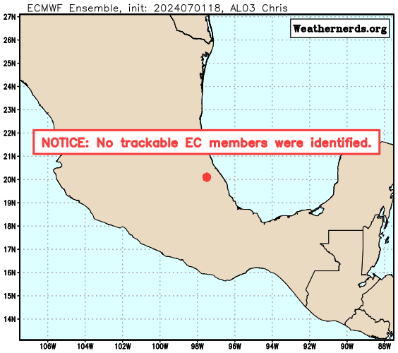
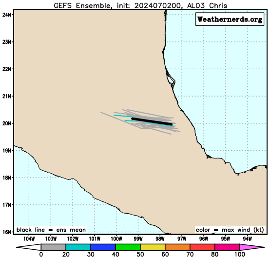
Tracking Chris – 2024 Atlantic Hurricane Season
NHC Important Links: NHC Discussion / Public Advisory / Forecast Advisory / Wind Probs / NWS Local Products / US Watch/Warning / Graphics / Storm Archive
Storm Tracking Important Links:
Wind Analysis /
Coastal Inundation Info /
Tide Information /
Surge Map /
Surge Potential /
Coastal Risk Map /
Microwave Imagery /
Advanced Dvorak ADT /
GOES16 Satellite Storm Page /
FSU Track Probability /
NOAA Tracker /
Albany Tracker /
Navy NRL Page /
HFIP Products /
Tropical Atlantic Storm Page /
NCAR Guidance Page /
CyclonicWX Tracker /
CIMSS Tracker / Tropical Tidbits Storm Page /UWM Tracker / SFWMD Models

Average Days For System To Reach U.S.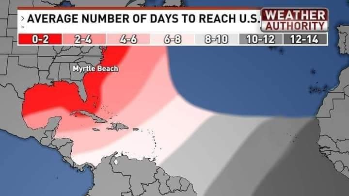
WeatherNerds.org Floaters

|

|

|

|
Most Likely Arrival Time of Tropical Storm Force Winds

Windshear Around Storm

Other Floater Sites:TropicalTidbits - NRL Floaters - CyclonicWx - RAMMB Sat -
RAMMB Model Data -
RAMMB Wind Products
Most Reasonable Arrival Time of Tropical Storm Force Winds

Dry Air/ Water Vapor Around Storm

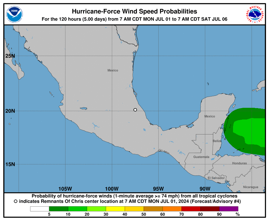
Hurricane Force Wind Probabilities

Intensity Forecasts

Tropical Storm Force Wind Probabilities

Top Analog Tracks

Model Tracks


Microwave Imagery

Key Messages

EURO Ensemble Tracks
NOAA NESDIS Floaters


GFS Ensemble Tracks


- Sun, 10 Nov 2024 20:32:06 +0000: Atlantic Post-Tropical Cyclone Rafael Advisory Number 30 - Atlantic Post-Tropical Cyclone Rafael Advisory Number 30
000
WTNT33 KNHC 102032
TCPAT3
BULLETIN
Post-Tropical Cyclone Rafael Advisory Number 30
NWS National Hurricane Center Miami FL AL182024
300 PM CST Sun Nov 10 2024
...RAFAEL DEGENERATES TO A POST-TROPICAL REMNANT LOW...
...THIS IS THE FINAL NHC ADVISORY...
SUMMARY OF 300 PM CST...2100 UTC...INFORMATION
----------------------------------------------
LOCATION...26.1N 91.3W
ABOUT 345 MI...560 KM NNW OF PROGRESO MEXICO
MAXIMUM SUSTAINED WINDS...35 MPH...55 KM/H
PRESENT MOVEMENT...E OR 90 DEGREES AT 3 MPH...6 KM/H
MINIMUM CENTRAL PRESSURE...1006 MB...29.71 INCHES
WATCHES AND WARNINGS
--------------------
There are no coastal watches or warnings in effect.
DISCUSSION AND OUTLOOK
----------------------
At 300 PM CST (2100 UTC), the center of Post-Tropical Cyclone Rafael
was located near latitude 26.1 North, longitude 91.3 West. The
post-tropical cyclone is moving toward the east near 3 mph (6 km/h).
The remnant low is expected to meander over the central Gulf of
Mexico through tonight, then turn toward the south and
south-southwest on Monday and Tuesday.
Maximum sustained winds have decreased to near 35 mph (55 km/h) with
higher gusts. The remnant low is forecast to dissipate by Tuesday
night.
The estimated minimum central pressure is 1006 mb (29.71 inches).
HAZARDS AFFECTING LAND
----------------------
Key messages can be found in the Tropical Cyclone Discussion under
AWIPS header MIATCDAT3 and WMO header WTNT43 KNHC and on the web at
hurricanes.gov/text/MIATCDAT3.shtml
SURF: Swells will continue impacting portions of the northern and
western Gulf Coast through Monday. These swells are likely to cause
life-threatening surf and rip current conditions. Please consult
products from your local weather office.
NEXT ADVISORY
-------------
This is the last public advisory issued by the National Hurricane
Center on Rafael. Additional information on this system can be found
in High Seas Forecasts issued by the National Weather Service, under
AWIPS header NFDHSFAT1, WMO header FZNT01 KWBC, and online at
ocean.weather.gov/shtml/NFDHSFAT1.php
$$
Forecaster Reinhart
- Sun, 10 Nov 2024 20:31:36 +0000: Atlantic Post-Tropical Cyclone RAFAEL Forecast/Adv... - Atlantic Post-Tropical Cyclone RAFAEL Forecast/Advisory Number 30 NWS NATIONAL Hurricane CENTER MIAMI FL AL182024 2100 UTC SUN NOV 10 2024 POST-TROPICAL Cyclone CENTER LOCATED NEAR 26.1N 91.3W AT 10/2100Z POSITION ACCURATE WITHIN 30 NM PRESENT MOVEMENT TOWARD THE EAST OR 90 DEGREES AT 3 KT ESTIMATED MINIMUM CENTRAL PRESSURE 1006 MB MAX SUSTAINED WINDS 30 KT WITH GUSTS TO 40 KT. 12 FT SEAS.. 75NE 0SE 0SW 0NW. WINDS AND SEAS VARY GREATLY IN EACH QUADRANT. RADII IN NAUTICAL MILES ARE THE LARGEST RADII EXPECTED ANYWHERE IN THAT QUADRANT. REPEAT...CENTER LOCATED NEAR 26.1N 91.3W AT 10/2100Z AT 10/1800Z CENTER WAS LOCATED NEAR 26.2N 91.5W FORECAST VALID 11/0600Z 25.8N 90.9W...POST-TROP/REMNT LOW MAX WIND 25 KT...GUSTS 35 KT. FORECAST VALID 11/1800Z 25.1N 90.7W...POST-TROP/REMNT LOW MAX WIND 25 KT...GUSTS 35 KT. FORECAST VALID 12/0600Z 24.1N 91.0W...POST-TROP/REMNT LOW MAX WIND 20 KT...GUSTS 30 KT. FORECAST VALID 12/1800Z 23.2N 92.0W...POST-TROP/REMNT LOW MAX WIND 20 KT...GUSTS 30 KT. FORECAST VALID 13/0600Z...DISSIPATED REQUEST FOR 3 HOURLY SHIP REPORTS WITHIN 300 MILES OF 26.1N 91.3W THIS IS THE LAST FORECAST/Advisory ISSUED BY THE NATIONAL HURRICANE CENTER ON RAFAEL. ADDITIONAL INFORMATION ON THIS SYSTEM CAN BE FOUND IN HIGH SEAS FORECASTS ISSUED BY THE NATIONAL WEATHER SERVICE...UNDER AWIPS HEADER NFDHSFAT1 AND WMO HEADER FZNT01 KWBC. $$ FORECASTER REINHART
000
WTNT23 KNHC 102031
TCMAT3
POST-TROPICAL CYCLONE RAFAEL FORECAST/ADVISORY NUMBER 30
NWS NATIONAL HURRICANE CENTER MIAMI FL AL182024
2100 UTC SUN NOV 10 2024
POST-TROPICAL CYCLONE CENTER LOCATED NEAR 26.1N 91.3W AT 10/2100Z
POSITION ACCURATE WITHIN 30 NM
PRESENT MOVEMENT TOWARD THE EAST OR 90 DEGREES AT 3 KT
ESTIMATED MINIMUM CENTRAL PRESSURE 1006 MB
MAX SUSTAINED WINDS 30 KT WITH GUSTS TO 40 KT.
12 FT SEAS.. 75NE 0SE 0SW 0NW.
WINDS AND SEAS VARY GREATLY IN EACH QUADRANT. RADII IN NAUTICAL
MILES ARE THE LARGEST RADII EXPECTED ANYWHERE IN THAT QUADRANT.
REPEAT...CENTER LOCATED NEAR 26.1N 91.3W AT 10/2100Z
AT 10/1800Z CENTER WAS LOCATED NEAR 26.2N 91.5W
FORECAST VALID 11/0600Z 25.8N 90.9W...POST-TROP/REMNT LOW
MAX WIND 25 KT...GUSTS 35 KT.
FORECAST VALID 11/1800Z 25.1N 90.7W...POST-TROP/REMNT LOW
MAX WIND 25 KT...GUSTS 35 KT.
FORECAST VALID 12/0600Z 24.1N 91.0W...POST-TROP/REMNT LOW
MAX WIND 20 KT...GUSTS 30 KT.
FORECAST VALID 12/1800Z 23.2N 92.0W...POST-TROP/REMNT LOW
MAX WIND 20 KT...GUSTS 30 KT.
FORECAST VALID 13/0600Z...DISSIPATED
REQUEST FOR 3 HOURLY SHIP REPORTS WITHIN 300 MILES OF 26.1N 91.3W
THIS IS THE LAST FORECAST/ADVISORY ISSUED BY THE NATIONAL HURRICANE
CENTER ON RAFAEL. ADDITIONAL INFORMATION ON THIS SYSTEM CAN BE FOUND
IN HIGH SEAS FORECASTS ISSUED BY THE NATIONAL WEATHER
SERVICE...UNDER AWIPS HEADER NFDHSFAT1 AND WMO HEADER FZNT01 KWBC.
$$
FORECASTER REINHART
- Sun, 10 Nov 2024 20:32:37 +0000: Atlantic Post-Tropical Cyclone Rafael Discussion Number 30 - Atlantic Post-Tropical Cyclone Rafael Discussion Number 30
000
WTNT43 KNHC 102032
TCDAT3
Post-Tropical Cyclone Rafael Discussion Number 30
NWS National Hurricane Center Miami FL AL182024
300 PM CST Sun Nov 10 2024
The limited convection that Rafael was producing in its eastern
semicircle has collapsed. Surface observations, visible satellite
images, and a 1530z ASCAT-C pass show the surface circulation has
become poorly defined and very elongated in the north-south
direction. Since Rafael does not possess a well-defined center or
organized convection, it no longer meets the definition of a
tropical cyclone. This will be the final NHC advisory on Rafael.
The remnant low is expected to drift eastward over the central Gulf
of Mexico tonight, then turn toward the south and southwest on
Monday and Tuesday. The forecast calls for dissipation by Tuesday
night, but this could occur even sooner if current trends continue.
The elevated rip current risk along the northern and western Gulf
Coast will likely continue into Monday. For more information, see
products from your local NWS forecast office.
Additional information can be found in High Seas Forecasts issued by
the National Weather Service, under AWIPS header NFDHSFAT1, WMO
header FZNT01 KWBC, and online at
ocean.weather.gov/shtml/NFDHSFAT1.php
Key Messages:
1. Swells are likely to cause life-threatening surf and rip current
conditions along portions of the Gulf Coast through Monday.
FORECAST POSITIONS AND MAX WINDS
INIT 10/2100Z 26.1N 91.3W 30 KT 35 MPH...POST-TROPICAL
12H 11/0600Z 25.8N 90.9W 25 KT 30 MPH...POST-TROP/REMNT LOW
24H 11/1800Z 25.1N 90.7W 25 KT 30 MPH...POST-TROP/REMNT LOW
36H 12/0600Z 24.1N 91.0W 20 KT 25 MPH...POST-TROP/REMNT LOW
48H 12/1800Z 23.2N 92.0W 20 KT 25 MPH...POST-TROP/REMNT LOW
60H 13/0600Z...DISSIPATED
$$
Forecaster Reinhart
2 Day Tropical Weather Outlook
7 Day Tropical Weather Outlook