For several hundred years, many hurricanes in the West Indies were named after the particular saint's day on which the hurricane occurred. Ivan R. Tannehill describes in his book "Hurricanes" the major tropical storms of recorded history and mentions many hurricanes named after saints. For example, there was "Hurricane Santa Ana" which struck Puerto Rico with exceptional violence on July 26, 1825, and "San Felipe" (the first) and "San Felipe" (the second) which hit Puerto Rico on September 13 in both 1876 and 1928.
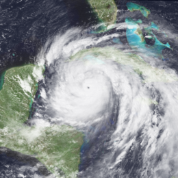
The first known meteorologist to assign names to tropical cyclones was Clement Wragge, an Australian meteorologist. Before the end of the l9th century, he began by using letters of the Greek alphabet, then from Greek and Roman mythology and progressed to the use of feminine names. In the United states, an early example of the use of a woman's name for a storm was in the novel "Storm" by George R. Stewart, published by Random House in 1941. During World War II, this practice became widespread in weather map discussions among forecasters, especially Air Force and Navy meteorologists who plotted the movements of storms over the wide expanses of the Pacific Ocean.

In 1953, the United States abandoned a confusing a two-year old plan to name storms by a phonetic alphabet (Able, Baker, Charlie, etc.). That year, this Nation's weather services began using female names for storms. The practice of naming hurricanes solely after women came to an end in 1978 when men's and women's names were included in the Eastern North Pacific storm lists. In 1979, male and female names were included in lists for the Atlantic and Gulf of Mexico.
Why Tropical Cyclones Are Named

Experience shows that the use of short, distinctive given names in written as well as spoken communications is quicker and less subject to error than the older more cumbersome latitude-longitude identification methods. These advantages are especially important in exchanging detailed storm information between hundreds of widely scattered stations, airports, coastal bases, and ships at sea.
The use of easily remembered names greatly reduces confusion when two or more tropical storms occur at the same time. For example, one hurricane can be moving slowly westward in the Gulf of Mexico, while at exactly the same time another hurricane can be moving rapidly northward along the Atlantic coast. In the past, confusion and false rumors have arisen when storm advisories broadcast from one radio station were mistaken for warnings concerning an entirely different storm located hundreds of miles away.

The name lists have an international flavor because hurricanes affect other nations and are tracked by the public and weather services of countries other than the United States. Names for these lists agreed upon by the nations involved during international meetings of the World Meteorological Organization.
The only time that there is a change in the list is if a storm is so deadly or costly that the future use of its name on a different storm would be inappropriate for reasons of sensitivity. If that occurs, then at an annual meeting by the WMO committee (called primarily to discuss many other issues) the offending name is stricken from the list and another name is selected to replace it.
Some notable tropical cyclones.
Atlantic Names
| 2015 |
2016 |
2017 |
2018 |
2019 |
2020 |
| Ana
Bill
Claudette
Danny
Erika
Fred
Grace
Henri
Ida
Joaquin
Kate
Larry
Mindy
Nicholas
Odette
Peter
Rose
Sam
Teresa
Victor
Wanda |
Alex
Bonnie
Colin
Danielle
Earl
Fiona
Gaston
Hermine
Ian
Julia
Karl
Lisa
Matthew
Nicole
Otto
Paula
Richard
Shary
Tobias
Virginie
Walter |
Arlene
Bret
Cindy
Don
Emily
Franklin
Gert
Harvey
Irma
Jose
Katia
Lee
Maria
Nate
Ophelia
Philippe
Rina
Sean
Tammy
Vince
Whitney |
Alberto
Beryl
Chris
Debby
Ernesto
Florence
Gordon
Helene
Isaac
Joyce
Kirk
Leslie
Michael
Nadine
Oscar
Patty
Rafael
Sara
Tony
Valerie
William |
Andrea
Barry
Chantal
Dorian
Erin
Fernand
Gabrielle
Humberto
Imelda
Jerry
Karen
Lorenzo
Melissa
Nestor
Olga
Pablo
Rebekah
Sebastien
Tanya
Van
Wendy |
Arthur
Bertha
Cristobal
Dolly
Edouard
Fay
Gonzalo
Hanna
Isaias
Josephine
Kyle
Laura
Marco
Nana
Omar
Paulette
Rene
Sally
Teddy
Vicky
Wilfred |
| Greek Alphabet: Alpha, Beta, Gamma, Delta, Epsilon, Zeta, Eta, Theta, Iota, Kappa, Lambda, Mu, Nu, Xi, Omicron, Pi, Rho, Sigma, Tau, Upsilon, Phi, Chi, Psi, Omega |
| Retired hurricane Names: Atlantic Basin (Updated as of 2017 Season) |
| A's |
Allison (2001), Andrew (1992), Alicia (1983), Allen (1980), Anita (1977), Agnes (1972), Audrey (1957) |
| B's |
Bob (1991), Beulah (1967), Betsy (1965) |
| C's |
Charley (2004), Cesar (1996), Carmen (1974), Celia (1970), Camille (1969), Carol (1965), Cleo (1964), Carla (1961), Connie (1955) |
| D's |
Dean (2007), Dennis (2005), Diana (1990), David (1979), Dora (1964), Donna (1960), Diane (1955) |
| E's |
Erika (2015), Elena (1985), Eloise (1975), Edna (1968) |
| F's |
Felix (2007), Frances (2004), Fabian (2003), Floyd (1999), Fran (1996), Frederic (1979), Fifi (1974), Flora (1963) |
| G's |
Gustav (2008), Georges (1998), Gilbert (1988), Gloria (1985), Gracie (1959) |
| H's |
Harvey (2017), Hortense (1996), Hugo (1989), Hilda (1964), Hattie (1961), Hazel (1954) |
| I's |
Irma (2017), Ingrid (2013), Irene (2011), Igor (2010), Ike (2008), Ivan (2004), Isabel (2003), Isidore (2002), Iris (2001), Inez (1966), Ione (1955) |
| J's |
Joaquin (2015), Jeanne (2004), Juan (2003), Joan (1988), Janet (1955) |
| K's |
Katrina (2005), Keith (2000), Klaus (1990) |
| L's |
Lili (2002), Lenny (1999), Luis (1995) |
| M's |
Maria (2017), Matthew (2016), Michelle (2001), Mitch (1998), Marilyn (1995) |
| N's |
Nate (2017), Noel (2007) |
| O's |
Otto (2016), Opal (1995) |
| P's |
Paloma (2008) |
| R's |
Rita (2005), Roxanne (1995) |
| S's |
Sandy (2012), Stan (2005) |
| T's |
Tomas (2010) |
| W's |
Wilma (2005) |
The
National Hurricane Center (RSMC Miami, FL), is responsible for the Atlantic basin west of 30°W. If a disturbance intensifies into a tropical storm the Center will give the storm a name from one of the six lists below.
A separate set is used each year beginning with the first name in the set. After the sets have all been used, they will be used again. The 2015 set, for example, will be used again to name storms in the year 2021.
The letters Q, U, X, Y, and Z are not included because of the scarcity of names beginning with those letters. If over 21 named tropical cyclones occur in a year, the Greek alphabet will be used following the "W" name.
In addition, after major land-falling storms having major economic impact, the names are retired.
Tracking charts (pdf)
Atlantic Basin
 |
Gulf of Mexico

|
Eastern North Pacific Names
| 2015 |
2016 |
2017 |
2018 |
2019 |
2020 |
| Andres
Blanca
Carlos
Dolores
Enrique
Felicia
Guillermo
Hilda
Ignacio
Jimena
Kevin
Linda
Marty
Nora
Olaf
Patricia
Rick
Sandra
Terry
Vivian
Waldo
Xina
York
Zelda |
Agatha
Blas
Celia
Darby
Estelle
Frank
Georgette
Howard
Isis
Javier
Kay
Lester
Madelime
Newton
Orlene
Paine
Roslyn
Seymour
Tina
Virgil
Winifred
Xavier
Yolanda
Zeke |
Adrian
Beatriz
Calvin
Dora
Eugene
Fernanda
Greg
Hilary
Irwin
Jova
Kenneth
Lidia
Max
Norma
Otis
Pilar
Ramon
Selma
Todd
Veronica
Wiley
Xina
York
Zelda |
Aletta
Bud
Carlotta
Daniel
Emilia
Fabio
Gilma
Hector
Ileana
John
Kristy
Lane
Miriam
Norman
Olivia
Paul
Rosa
Sergio
Tara
Vicente
Willa
Xavier
Yolanda
Zeke |
Alvin
Barbara
Cosme
Dalilia
Erick
Flossie
Gil
Henriette
Ivo
Juliette
Kiko
Lorena
Mario
Narda
Octave
Priscilla
Raymond
Sonia
Tico
Velma
Wallis
Xina
York
Zelda |
Amanda
Boris
Cristina
Douglas
Elida
Fausto
Genevieve
Hernan
Iselle
Julio
Karina
Lowell
Marie
Norbert
Odalys
Polo
Rachel
Simon
Trudy
Vance
Winnie
Xavier
Yolanda
Zeke |
The
National Hurricane Center (RSMC Miami, FL), is also responsible for the North East Pacific basin east of 140°W.
If a disturbance intensifies into a tropical storm the Center will give the storm a name from one of the six lists below. A separate set is used each year beginning with the first name in the set.
After the sets have all been used, they will be used again. The 2015 set, for example, will be used again to name storms in the year 2021.
Tracking charts (pdf)
Eastern Pacific
|
Central North Pacific Names
| List 1 |
List 2 |
List 3 |
List 4 |
| Akoni
Ema
Hone
Iona
Keli
Lala
Moke
Nolo
Olana
Pena
Ulana
Wale |
Aka
Ekeka
Hene
Iolana
Keoni
Lino
Mele
Nona
Oliwa
Pama
Upana
Wene |
Alika
Ele
Huko
Iopa
Kika
Lana
Maka
Neki
Omeka
Pewa
Unala
Wali |
Ana
Ela
Halola
Iune
Kilo
Loke
Malia
Niala
Oho
Pali
Ulika
Walaka |
 Central Pacific Hurricane Center
 (RSMC Honolulu) area of responsibility is from 140°W longitude to 180° longitude. The names below are used one after the other. When the bottom of one list is reached, the next name is the top of the next list.
Western North Pacific Ocean/South China Sea
| Contributed by |
I |
II |
III |
IV |
V |
| Cambodia
China
North Korea
Hong Kong
Japan
Laos
Macau
Malaysia
Micronesia
Philippines
South Korea
Thailand
U.S.A.
Viet Nam
Cambodia
China
North Korea
Hong Kong
Japan
Laos
Macau
Malaysia
Micronesia
Philippines
South Korea
Thailand
U.S.A.
Viet Nam |
Damrey
Haikui
Kirogi
Kai-Tak
Tembin
Bolaven
Sanba
Jelawat
Ewiniar
Malaksi
Gaemi
Prapiroon
Maria
Son-Tinh
Ampil
Wukong
Jongdari
Shanshan
Yagi
Leepi
Bebinca
Rumbia
Soulik
Cimaron
Jebi
Mangkhut
Barijet
Trami |
Kong-Rey
Yutu
Toraji
Man-yi
Usagi
Pabuk
Wutip
Sepat
Mun
Danas
Nari
Wipha
Francisco
Lekima
Krosa
Bailu
Podul
Lingling
Kajiki
Faxai
Peipah
Tapah
Mitag
Hagibis
Neoguri
Rammasun
Matmo
Halong |
Nakri
Fengshen
Kalmaegi
Fung-wong
Kanmuri
Phanfone
Vongfong
Nuri
Sinlaku
Hagupit
Jangmi
Mekkhala
Higos
Bavi
Maysak
Haishen
Noul
Dolphin
Kujira
Chan-hom
Linfa
Nangka
Soudelor
Molave
Goni
Atsani
Etau
Vamco |
Krovanh
Dujuan
Mujigae
Choi-wan
Koppu
Champi
In-fa
Melor
Nepartak
Lupit
Mirinae
Nida
Omais
Conson
Chanthu
Dianmu
Mindulle
Lionrock
Kompasu
Namtheun
Malou
Meranti
Rai
Malakas
Megi
Chaba
Aere
Songda |
Sarika
Haima
Meari
Ma-on
Tokage
Nock-Ten
Muifa
Merbok
Nanmadol
Talas
Noru
Kulap
Roke
Sonca
Nesat
Haitang
Nalgae
Banyan
Hato
Pakhar
Sanvu
Mawar
Guchol
Talim
Doksuri
Khanun
Lan
Saola |
 RSMC Tokyo - Typhoon Center
 is responsible for the western North Pacific (west of 180°) and the South China Sea.
The practice of naming storms, which usually brings destruction, after persons appears to run counter to Oriental sensibilities.
Thus, Asians like the Japanese and Chinese prefer to name their storms after other living things and also after inanimate objects like flowers, rivers etc.
These names are used sequentially. If the last storm of the year is Cimaron, the first storm of the next year is Jebi.
Australian Region Names
|
I |
II |
III |
IV |
V |
| A
B
C
D
E
F
G
H
I
J
K
L
M
N
O
P, Q
R
S
T
U, V
W, X, Y, Z |
Anika
Billy
Charlotte
Dominic
Ellie
Freddy
Gabrielle
Herman
Ilsa
Jasper
Kirrily
Lincoln
Megan
Neville
Olga
Paul
Robyn
Sean
Tasha
Vince
Zelia |
Anthony
Bianca
Courtney
Dianne
Errol
Fina
Grant
Heidi
Iggy
Jenna
Koji
Luana
Mitchell
Narelle
Oswald
Peta
Rusty
Sandra
Tim
Victoria
Zane |
Alessia
Bruce
Catherine
Dylan
Edna
Fletcher
Gillian
Hadi
Ivana
Jack
Kate
Lam
Marcia
Nathan
Olwyn
Quang
Rachel
Stan
Tatjana
Uriah
Yvette |
Alfred
Blanche
Caleb
Debbie
Ernie
Frances
Greg
Hilda
Ilsobel
Joyce
Kelvin
Linda
Marcus
Nora
Owen
Penny
Riley
Savannah
Trevor
Veronica
Wallace |
Ann
Blake
Claudia
Damien
Esther
Ferdinand
Gretel
Harold
Imogen
Joshua
Kimi
Lucas
Marian
Noah
Odette
Paddy
Ruby
Seth
Tiffany
Verdun |

There is a single list of names that are used by all of the
Bureau of Meteorology Tropical Cyclone Warning Centres (TCWC). This single list was introduced for the start of the 2008/09 season, replacing the three lists that existed previously.
The name of a new tropical cyclone is usually selected from this list of names. If a named cyclone moves into the Australian region from another country's zone of responsibility, the name assigned by that other country will be retained. The names are normally chosen in sequence, when the list is exhausted, we return to the start of the list.
The
Perth TCWC area of responsibility is the Southeast Indian Ocean. The
Darwin TCWC area of responsibility is Arafura Sea and the Gulf of Carpenteria of north Australia. The
Brisbane TCWC is responsible for the Coral Sea off northeast Australia.
Port Moresby, Papua New Guinea Names
| List A |
List B |
| Alu
Buri
Dodo
Emau
Fere
Hibu
Ila
Kama
Lobu
Maila |
Nou
Obaha
Paia
Ranu
Sabi
Tau
Ume
Vali
Wau
Auram |

The Port Moresby TCWC is responsible for the Solomon Sea and Gulf of Papua. The name of a new cyclone is determined by sequentially cycling through list A. Standby list B is used to replace retired names in List A and any replacement name will be added to the bottom of list A to maintain the alphabetical order.
Fiji Region Names
| List A |
List B |
List C |
List D |
Standby |
| Ana
Bina
Cody
Dovi
Eva
Fili
Gina
Hagar
Irene
Judy
Kerry
Lola
Mal
Nat
Olo
Pita
Rae
Sheila
Tam
Urmil
Vaianu
Wati
Xavier
Yani
Zita |
Arthur
Becky
Chip
Denia
Elisa
Fotu
Glen
Hettie
Innis
Joni
Ken
Lin
Mick
Nisha
Oli
Pearl
Rene
Sarah
Tomas
-
Vanessa
Wano
-
Yvonne
Zaka |
Alvin
Bune
Cyril
Daphne
Eden
Florin
Garry
Haley
Isa
June
Kofi
Louise
Mike
Niko
Opeti
Pam
Reuben
Solo
Tuni
Ula
Victor
Winston
-
Yalo
Zena |
Amos
Bart
Colin
Donna
Ella
Frank
Gita
Hali
Iris
Jo
Kala
Leo
Mona
Neil
Oma
Pami
Rita
Sarai
Tino
-
Vicky
Wiki
-
Yolanda
Zazu |
Aru
Bela
Cook
Dean
-
-
Garth
Hart
-
Julie
Kevin
-
Moses
-
-
-
Rex
Suki
Troy
-
Velma
Wanita
-
Yates
Zidane |

The
RSMC Nadi, in Fiji, are of responsibility is Southwest Pacific Ocean extending from 120° to 160°E and from the equator to 25°S.
Lists A, B, C, and D are used sequentially one after the other.
The first name in any given year is the one immediately following the last name from the previous year.
'Standby' is a list of replacement names if they become necessary.
Southwest Indian Ocean Names
| 2014-15 |
| Contributed by |
Name |
| Kenya
Mozambique
Mauritius
Tanzania
Zimbabwe
Malawi
Seychelles
Comores
Madagascar
Botswana
Lesotho
South Africa
France
Swaziland
Mauritius
Malawi
Seychelles
Botswana
Comores
France
Kenya
South Africa
Mozambique
Madagascar
Swaziland
Tanzania |
Adjali
Bansi
Chedza
Diamondra
Eunice
Fundi
Glenda
Haliba
Ikola
Joalane
Kesha
Lugenda
Mahara
Nathan
Oscar
Puleng
Quotto
Roselina
Sitara
Tarik
Umali
Vuntu
Wezi
Xolani
Yolande
Zita |

The
RSMC La Réunion area of responsibility is Southwest Indian Ocean. Madagascar, Reunion, Seychelles, Comores, and
Mauritius use a common list of names for identifying tropical depressions.
Mauritius is responsible for naming depressions forming in the region lying between longitude 55°E and 90°E. Madagascar is responsible for the region west of longitude 55°E.
Whenever a cyclone moves from the Australian region of responsibility to that of Mauritius, it is given a hyphenated name comprising the names from both regions for a period of about 24 hours. Thereafter it is known by the South West Indian Ocean name.
North Indian Ocean
| Contributed by |
List 1 |
List 2 |
List 3 |
List 4 |
| Bangladesh
India
Maldives
Myanmar
Oman
Pakistan
Sri Lanka
Thailand |
Onil
Agni
Hibaru
Pyarr
Baaz
Fanoos
Mala
Mukda |
Ogni
Akash
Gonu
Yemyin
Sidr
Nargis
Rashmi
Khai-Muk |
Nisha
Bijli
Aila
Phyan
Ward
Laila
Bandu
Phet |
Giri
Jal
Keila
Thane
Murjan
Nilam
Viyaru
Phailin |
| Contributed by |
List 5 |
List 6 |
List 7 |
List 8 |
| Bangladesh
India
Maldives
Myanmar
Oman
Pakistan
Sri Lanka
Thailand |
Helen
Lehar
Madi
Nanauk
Hudhud
Nilofar
Ashobaa
Komen |
Chapala
Megh
Roanu
Kyant
Nada
Vardah
Maarutha
Mora |
Ockhi
Sagar
Mekunu
Daye
Luban
Titli
Gaje
Phethai |
Fani
Vayu
Hikaa
Kyarr
Maha
Bulbul
Pawan
Amphan |
 RSMC New Delhi, India
 is responsible for the Bay of Bengal and the Arabian Sea.
These lists will be used sequentially. The first name in any given year is the one immediately following the last name from the previous year.