Hurricane Season starts early…
For the third consecutive year in a row, activity began early, with the formation of Tropical Storm Arlene on April 19, nearly a month and a half before the official start of the season which begins on June 1st. It is only the second named storm on record to exist in the month of April, with the first being Ana in 2003. On average, an Atlantic hurricane season between 1981 and 2010 contained 12 tropical storms, 6 hurricanes with 2 of those becoming major hurricanes with an Accumulated Cyclone Energy (ACE) index of between 66 and 103 units.
The 2016 Atlantic hurricane season came in slightly above average with a total of 15 named storms, 7 hurricanes and 3 major hurricanes. These forecasts were generally in line with the hurricane predictions issued by both the Tropical Meteorology Project at CSU as well as the Tropical Storm Risk forecasting consortium. For example, the hurricane predictions issued in early August by CSU called for a total of 15 named storms, 6 hurricanes and 2 major hurricanes, while the forecast issued by TSR correctly called for exactly 15 named storms, 7 hurricanes and 3 major hurricanes. GWO was very close in 2016 forecasting 17 named storms, 9 hurricanes, and 4 major hurricanes.
Below are the 2017 seasonal forecasts from all of the major organizations…
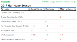 A lot of these forecasts below are depending on if an El Niño develops in the Eastern Pacific. This periodic warming of the central and eastern equatorial waters of the Pacific Ocean tends to produce areas of stronger wind shear (the change in wind speed with height) and sinking air in parts of the Atlantic Basin that is hostile to either the development or maintenance of tropical cyclones. But there remains plenty of uncertainty regarding El Niño’s possible development, and therefore, how much of an effect it could have on the hurricane season. The only organization and outlier to forecast an above average season without an El Niño this year is GWO.
Colorado State University (CSU) is forecasting a BELOW AVERAGE Season with a total of 11 named storms, 4 hurricanes which 2 of those will be major hurricanes and an Accumulated Cyclone Energy (ACE) of 75. The CSU outlook also calls for a 42% chance of a major hurricane hitting the U.S. in 2017, with a 24% chance for the East Coast and Florida Peninsula and a 24% chance for the Gulf Coast. The Caribbean is forecast to have a 34% chance of seeing at least one major hurricane. The forecast prepared by the CSU Tropical Meteorology Project, headed by Dr. Phil Klotzbach is slightly below the 30 year average from 1981 – 2010. They are saying a quiet season is expected due to cooling SSTs, and El Niño.
Tropical Storm Risk, Inc. (TSR) is also forecasting a BELOW AVERAGE Season with a total of 11 named storms, 4 hurricanes which 2 of those will be major hurricanes. They project that two named storms but no hurricanes will hit the U.S. The averages from the 1950-2016 climatology are three named storms and one hurricane. Their below average forecast is also due to the anticipated development of a moderate El Niño by the summer/autumn of 2017.
The Weather Channel (TWC) is forecasting an AVERAGE Season with a total of 12 named storms, 6 hurricanes which 2 of those will be major hurricanes. This forecast matches the 30-year average (1981-2010) of storms for the Atlantic basin. The 2017 Atlantic hurricane season is forecast to be less active than a year ago with the number of named storms and hurricanes near historical averages, according to an outlook released Monday by The Weather Company, an IBM business. Their forecast is based on the cooling below average SSTs in the Tropical Atlantic and also the anticipated development of El Niño.
North Carolina State University (NCSU) also released their forecast predicting a NEAR-AVERAGE season with a total of 11–15 named storms, 4–6 hurricanes which they say 1–3 will be major hurricanes. Noting that numbers for the Gulf of Mexico indicate the likelihood of four to seven named storms, which would be slightly above the average of three named storms, with one to two of the storms becoming a hurricane. In the Caribbean, two to three tropical cyclones may form, with one to two becoming a hurricane, with one possible major hurricane.
AccuWeather.com is forecasting a BELOW average Season with 10 named storms, 5 of which are projected to become hurricanes and 3 of which may become major hurricanes. They also believe El Niño will come on board some time during the summer and will continue all the way through the rest of the hurricane season limiting the number of storms.
WeatherBELL.com is forecasting a BELOW average Season with 10-12 named storms, 4-6 hurricanes which 1-2 of those becoming major hurricanes and an Accumulated Cyclone Energy (ACE) of 75-95. Again, WeatherBELL also is going with the majority saying an El Niño developing would likely put a quicker end to the season but cautions that some big names have shown up in El Niño years.
Global Weather Oscillations (GWO) is the outlier going against all the major organizations and forecasting a DANGEROUS ABOVE average Season. David Dilley, Senior Meteorologist for GWO says the upcoming 2017 hurricane season will be stronger than last year, and it will be the most dangerous and costliest in 12 years for the United States with 16 named storms, 8 hurricanes and 4 of those becoming major hurricanes. Stating the potential for 6 named storms making United States landfalls. Dilley correctly predicted 8 months in advance that GWO’s prediction zones for the Florida Panhandle and Florida’s East Coast northward to North Carolina – would experience hurricane and/or strong tropical storm conditions in 2016, with multiple strikes likely. As predicted by GWO, the 2016 hurricane season was more dangerous and costlier than average. GWO says that 2017 will once again be influenced by a Climate Pulse Hurricane Enhancement Cycle – with very conducive conditions for hurricane development due to the lack of an El Niño, or La Niña conditions. In addition – ocean water temperatures continue to run warmer than normal across most of the Atlantic Basin, and especially in the Caribbean region and the Atlantic near the United States.
Here are the official 2017 Names: Arlene, Bret, Cindy, Don, Emily, Franklin, Gert, Harvey, Irma, Jose, Katia, Lee, Maria, Nate, Ophelia, Philippe, Rina, Sean, Tammy, Vince, Whitney
Note: There is no strong correlation between the number of storms or hurricanes and U.S. landfalls in any given season. One or more of the named storms forecast to develop this season could hit the U.S., or none at all. Therefore, residents of the coastal United States should prepare each year no matter the forecast.
A couple of classic examples of why you need to be prepared each year occurred in 1992 and 1983. The 1992 season produced only six named storms and one subtropical storm. However, one of those named storms was Hurricane Andrew, which devastated South Florida as a Category 5 hurricane. In 1983 there were only four named storms, but one of them was Alicia. The Category 3 hurricane hit the Houston-Galveston area and caused almost as many direct fatalities there as Andrew did in South Florida.
In contrast, the 2010 season was active. There were 19 named storms and 12 hurricanes that formed in the Atlantic Basin. Despite the large number of storms that year, not a single hurricane and only one tropical storm made landfall in the United States.
In other words, a season can deliver many storms, but have little impact, or deliver few storms and have one or more hitting the U.S. coast with major impact. So ALWAYS BE ALERT AND PREPARED NO MATTER WHAT THE FORECAST IS! You can rely on Louisiana Hurricane Center EVERY YEAR to bring you the latest and most accurate information on Hurricane Season 24/7… STAY TUNED!
 DONATE
![[Map of 1950-2017 CONUS Hurricane Strikes]](http://www.nhc.noaa.gov/climo/images/conus_strikes_sm.jpg)
