NOAA NESDIS Floaters


Other Floaters:
WeatherNerds - NRL Floaters - CyclonicWx - RAMMB Sat - RAMMB Model Data - RAMMB Wind Products


Other Floaters:
WeatherNerds - NRL Floaters - CyclonicWx - RAMMB Sat - RAMMB Model Data - RAMMB Wind Products
NHC Important Links:
NHC Discussion / Public Advisory
Forecast Advisory / Wind Probs
NWS Local / US Watch/Warning
NHC Graphics / Storm Archive
Storm Tracking Important Links: Wind Analysis / Coastal Inundation
Tide Information / Surge Potential
Coastal Risk Map / Microwave Imagery
Dvorak ADT / GOES16 Satellite
FSU Track Probability / Navy NRL
HFIP / Tropical Atlantic Storm Page
NCAR Guidance / CyclonicWX Tracker
CIMSS Tracker/ UWM Tracker
- Thu, 14 Nov 2024 17:45:42 +0000: Atlantic Tropical Storm Sara Intermediate Advisory Number 4A - Atlantic Tropical Storm Sara Intermediate Advisory Number 4A
000
WTNT34 KNHC 141745
TCPAT4
BULLETIN
Tropical Storm Sara Intermediate Advisory Number 4A
NWS National Hurricane Center Miami FL AL192024
100 PM EST Thu Nov 14 2024
...DEPRESSION STRENGTHENS INTO TROPICAL STORM SARA...
...LIFE-THREATENING AND POTENTIALLY CATASTROPHIC FLASH FLOODING AND
MUDSLIDES EXPECTED IN HONDURAS THROUGH THE WEEKEND...
SUMMARY OF 100 PM EST...1800 UTC...INFORMATION
----------------------------------------------
LOCATION...15.7N 82.9W
ABOUT 205 MI...330 KM ESE OF ISLA GUANAJA HONDURAS
ABOUT 50 MI...85 KM NE OF CABO GRACIAS A DIOS ON NIC/HON BORDER
MAXIMUM SUSTAINED WINDS...40 MPH...65 KM/H
PRESENT MOVEMENT...W OR 265 DEGREES AT 12 MPH...19 KM/H
MINIMUM CENTRAL PRESSURE...999 MB...29.50 INCHES
WATCHES AND WARNINGS
--------------------
CHANGES WITH THIS ADVISORY:
None.
SUMMARY OF WATCHES AND WARNINGS IN EFFECT:
A Tropical Storm Warning is in effect for...
* The northern coast of Honduras form Punta Sal eastward to the
Honduras/Nicaragua Border
* The Bay Islands of Honduras
A Tropical Storm Watch is in effect for...
* The northeastern coast of Nicaragua from Puerto Cabezas northward
to the Honduras/Nicaragua Border
A Tropical Storm Warning means that tropical storm conditions are
expected somewhere within the warning area.
A Tropical Storm Watch means that tropical storm conditions are
possible within the watch area, generally within 48 hours.
Interests elsewhere in Honduras, Guatemala, Belize and the
Yucatan Peninsula should monitor the progress of this system.
For storm information specific to your area, please monitor
products issued by your national meteorological service.
DISCUSSION AND OUTLOOK
----------------------
At 100 PM EST (1800 UTC), the center of Tropical Storm Sara was
located by Air Force Reserve reconnaissance aircraft near latitude
15.7 North, longitude 82.9 West. The system is moving toward the
west near 12 mph (19 km/h). This motion should continue through
today, bringing the center near the coast of eastern Honduras. The
system is expected to meander near the northern coast of Honduras
late Friday and through the weekend.
Data from the Air Force Reserve aircraft indicate that the maximum
sustained winds have increased to near 40 mph (65 km/h) with higher
gusts. Some strengthening is possible, if the system remains over
water.
Tropical-storm-force winds extend outward up to 70 miles (115 km)
from the center, mainly in the northern semicircle.
The estimated minimum central pressure based on dropsonde data is
999 mb (29.50 inches).
HAZARDS AFFECTING LAND
----------------------
Key Messages for Tropical Storm Sara can be found in the
Tropical Cyclone Discussion under AWIPS header MIATCDAT4 and WMO
header WTNT44 KNHC and on the web at
hurricanes.gov/text/MIATCDAT4.shtml
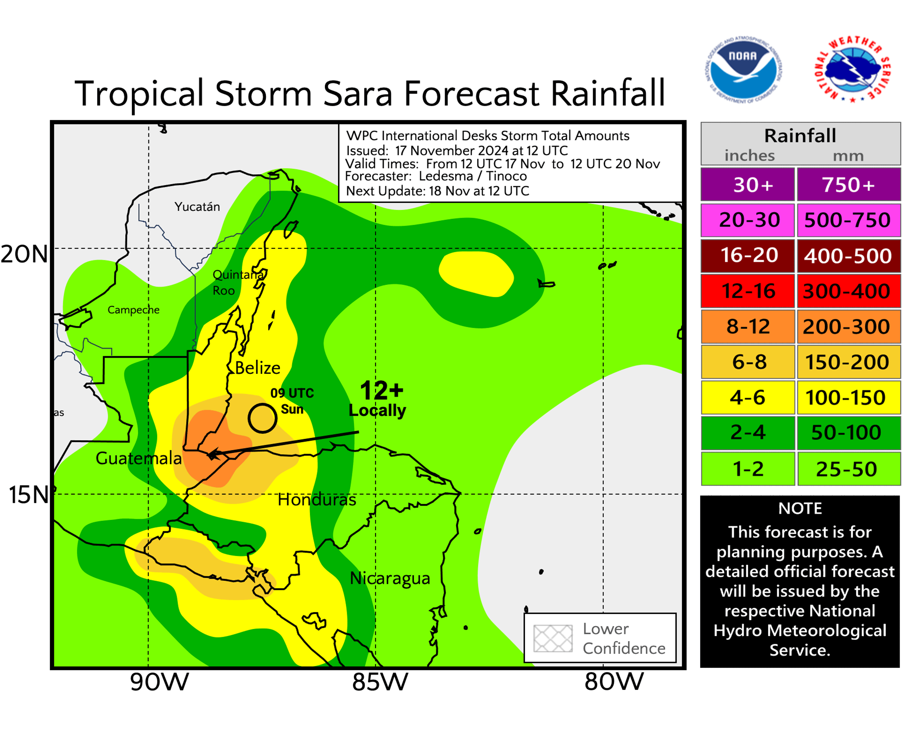
RAINFALL: Through early next week, rainfall amounts of 10
to 20 inches with isolated storm totals around 30 inches area
expected over northern Honduras. This rainfall will lead to
widespread areas of life-threatening and potentially catastrophic
flash flooding and mudslides, especially along and near the Sierra
La Esperanza.
Elsewhere across the rest of Honduras, Belize, El Salvador, eastern
Guatemala, and western Nicaragua, Tropical Storm Sara is
expected to produce 5 to 10 inches of rain with localized totals
around 15 inches through early next week. This will result in areas
of flash flooding, perhaps significant, along with the potential of
mudslides.
For a complete depiction of forecast rainfall associated with
Tropical Storm Sara, please see the National Weather
Service Storm Total Rainfall Graphic, available at
hurricanes.gov/refresh/graphics_at4+shtml/205755.shtml?
rainqpf#contents
WIND: Tropical storm conditions are expected in the warning area
and possible in the watch area beginning later today.
STORM SURGE: Storm surge could raise water levels by as much as 1
to 3 feet above normal tide levels along the immediate coast in
areas of onshore winds along the northern coast of Honduras. Near
the coast, the surge will be accompanied by large and destructive
waves.
NEXT ADVISORY
-------------
Next complete advisory at 400 PM EST.
$$
Forecaster Kelly
- Thu, 14 Nov 2024 14:49:03 +0000: Atlantic Tropical Depression NINETEEN Forecast/Adv... - Atlantic Tropical Depression NINETEEN Forecast/Advisory Number 4 NWS NATIONAL Hurricane CENTER MIAMI FL AL192024 1500 UTC THU NOV 14 2024 TROPICAL DEPRESSION CENTER LOCATED NEAR 15.7N 82.6W AT 14/1500Z POSITION ACCURATE WITHIN 40 NM PRESENT MOVEMENT TOWARD THE WEST OR 265 DEGREES AT 12 KT ESTIMATED MINIMUM CENTRAL PRESSURE 1004 MB MAX SUSTAINED WINDS 30 KT WITH GUSTS TO 40 KT. WINDS AND SEAS VARY GREATLY IN EACH QUADRANT. RADII IN NAUTICAL MILES ARE THE LARGEST RADII EXPECTED ANYWHERE IN THAT QUADRANT. REPEAT...CENTER LOCATED NEAR 15.7N 82.6W AT 14/1500Z AT 14/1200Z CENTER WAS LOCATED NEAR 15.7N 82.2W FORECAST VALID 15/0000Z 15.7N 83.7W MAX WIND 35 KT...GUSTS 45 KT. 34 KT... 40NE 20SE 20SW 40NW. FORECAST VALID 15/1200Z 15.9N 84.9W...NEAR THE COAST MAX WIND 40 KT...GUSTS 50 KT. 34 KT... 60NE 20SE 20SW 60NW. FORECAST VALID 16/0000Z 15.9N 85.4W...NEAR THE COAST MAX WIND 40 KT...GUSTS 50 KT. 34 KT... 60NE 20SE 20SW 70NW. FORECAST VALID 16/1200Z 15.9N 85.8W...NEAR THE COAST MAX WIND 40 KT...GUSTS 50 KT. 34 KT... 50NE 20SE 20SW 70NW. FORECAST VALID 17/0000Z 16.0N 86.2W...NEAR THE COAST MAX WIND 45 KT...GUSTS 55 KT. 34 KT... 60NE 20SE 20SW 60NW. FORECAST VALID 17/1200Z 16.2N 87.0W...OVER WATER MAX WIND 45 KT...GUSTS 55 KT. 34 KT... 50NE 30SE 30SW 50NW. EXTENDED OUTLOOK. NOTE...ERRORS FOR TRACK HAVE AVERAGED NEAR 125 NM ON DAY 4 AND 175 NM ON DAY 5...AND FOR INTENSITY NEAR 15 KT EACH DAY OUTLOOK VALID 18/1200Z 18.0N 89.6W...INLAND MAX WIND 30 KT...GUSTS 40 KT. OUTLOOK VALID 19/1200Z 21.7N 91.6W...OVER WATER MAX WIND 30 KT...GUSTS 40 KT. REQUEST FOR 3 HOURLY SHIP REPORTS WITHIN 300 MILES OF 15.7N 82.6W Intermediate PUBLIC Advisory...WTNT34 KNHC/MIATCPAT4...AT 14/1800Z NEXT ADVISORY AT 14/2100Z $$ FORECASTER KELLY
000
WTNT24 KNHC 141448
TCMAT4
TROPICAL DEPRESSION NINETEEN FORECAST/ADVISORY NUMBER 4
NWS NATIONAL HURRICANE CENTER MIAMI FL AL192024
1500 UTC THU NOV 14 2024
TROPICAL DEPRESSION CENTER LOCATED NEAR 15.7N 82.6W AT 14/1500Z
POSITION ACCURATE WITHIN 40 NM
PRESENT MOVEMENT TOWARD THE WEST OR 265 DEGREES AT 12 KT
ESTIMATED MINIMUM CENTRAL PRESSURE 1004 MB
MAX SUSTAINED WINDS 30 KT WITH GUSTS TO 40 KT.
WINDS AND SEAS VARY GREATLY IN EACH QUADRANT. RADII IN NAUTICAL
MILES ARE THE LARGEST RADII EXPECTED ANYWHERE IN THAT QUADRANT.
REPEAT...CENTER LOCATED NEAR 15.7N 82.6W AT 14/1500Z
AT 14/1200Z CENTER WAS LOCATED NEAR 15.7N 82.2W
FORECAST VALID 15/0000Z 15.7N 83.7W
MAX WIND 35 KT...GUSTS 45 KT.
34 KT... 40NE 20SE 20SW 40NW.
FORECAST VALID 15/1200Z 15.9N 84.9W...NEAR THE COAST
MAX WIND 40 KT...GUSTS 50 KT.
34 KT... 60NE 20SE 20SW 60NW.
FORECAST VALID 16/0000Z 15.9N 85.4W...NEAR THE COAST
MAX WIND 40 KT...GUSTS 50 KT.
34 KT... 60NE 20SE 20SW 70NW.
FORECAST VALID 16/1200Z 15.9N 85.8W...NEAR THE COAST
MAX WIND 40 KT...GUSTS 50 KT.
34 KT... 50NE 20SE 20SW 70NW.
FORECAST VALID 17/0000Z 16.0N 86.2W...NEAR THE COAST
MAX WIND 45 KT...GUSTS 55 KT.
34 KT... 60NE 20SE 20SW 60NW.
FORECAST VALID 17/1200Z 16.2N 87.0W...OVER WATER
MAX WIND 45 KT...GUSTS 55 KT.
34 KT... 50NE 30SE 30SW 50NW.
EXTENDED OUTLOOK. NOTE...ERRORS FOR TRACK HAVE AVERAGED NEAR 125 NM
ON DAY 4 AND 175 NM ON DAY 5...AND FOR INTENSITY NEAR 15 KT EACH DAY
OUTLOOK VALID 18/1200Z 18.0N 89.6W...INLAND
MAX WIND 30 KT...GUSTS 40 KT.
OUTLOOK VALID 19/1200Z 21.7N 91.6W...OVER WATER
MAX WIND 30 KT...GUSTS 40 KT.
REQUEST FOR 3 HOURLY SHIP REPORTS WITHIN 300 MILES OF 15.7N 82.6W
INTERMEDIATE PUBLIC ADVISORY...WTNT34 KNHC/MIATCPAT4...AT 14/1800Z
NEXT ADVISORY AT 14/2100Z
$$
FORECASTER KELLY
- Thu, 14 Nov 2024 14:50:07 +0000: Atlantic Tropical Depression Nineteen Discussion Number 4 - Atlantic Tropical Depression Nineteen Discussion Number 4
000
WTNT44 KNHC 141450
TCDAT4
Tropical Depression Nineteen Discussion Number 4
NWS National Hurricane Center Miami FL AL192024
1000 AM EST Thu Nov 14 2024
Latest satellite imagery depicts that the system continues to become
better organized this morning, with improved curved banding
features, and deep convection consolidating near the low-level
center. The latest subjective intensity estimates were T/2.5 from
both TAFB and SAB. The initial intensity is set to 30 kt, and an Air
Force Hurricane Hunter aircraft is about to enter the system which
will provide more information on current intensity and structure.
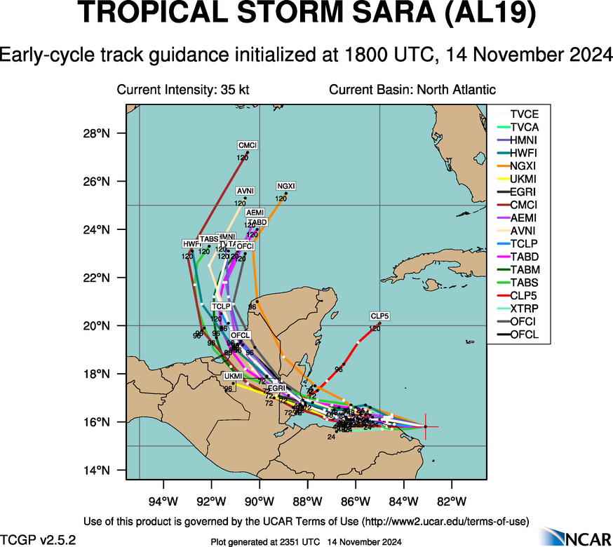
The cyclone is moving westward with an estimated motion of 265/12
kt. A strong mid-level ridge located to the north of the system will
continue steer the system westward towards Central America. The
ridge is expected to break down, and the cyclone will meander in
weak steering currents, Friday through the weekend. This expected
slow motion will cause the system to produce heavy rains over the
same region, likely causing life-threatening flooding over portions
of Central America. By early next week, the mid-level ridge should
slide eastward over Florida, which should cause the system to move
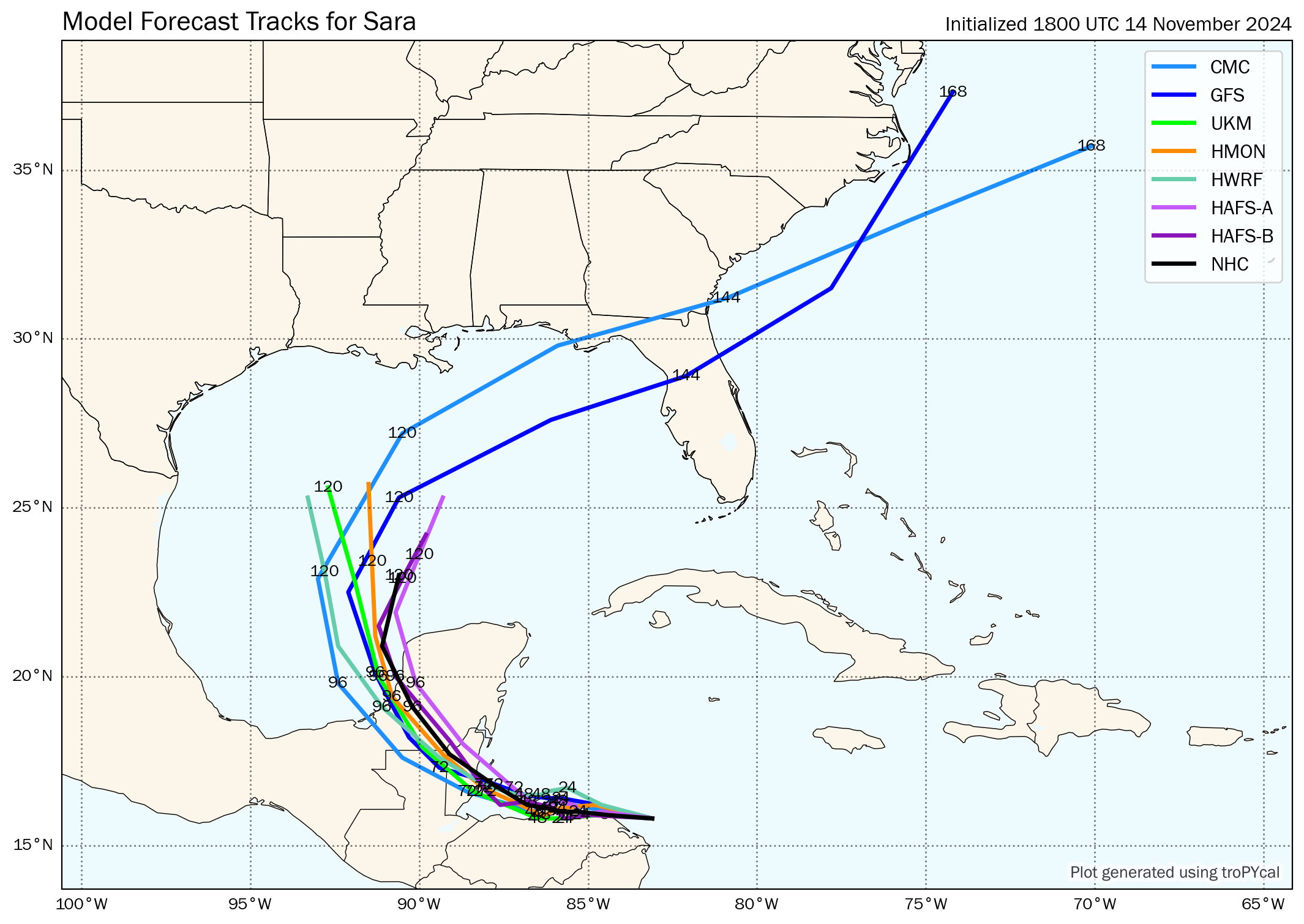
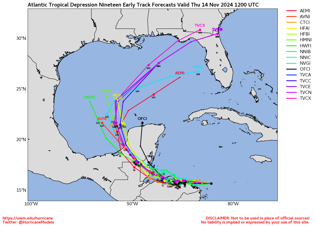
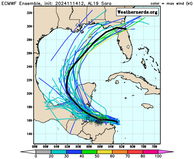
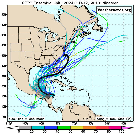
northwestward across Belize and the Yucatan Peninsula. The NHC track
forecast is in good agreement with the various consensus models, and
is nudged slightly left towards the latest model trends.
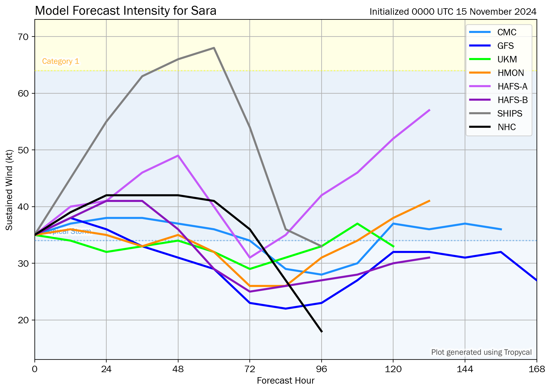
Environmental and oceanic conditions are conducive for some
strengthening during the next day or so while the cyclone remains
over water. There remains uncertainty in how much land interaction
there will be with Honduras during the next several days, but the
model trends have been southward showing more interaction. If the
system remains along the coast or just offshore, it will likely
maintain intensity or slightly strengthen. However, if the
depression moves a little south of the forecast track, the system
could be weaker than shown below. Given the slight leftward track
adjustment with potentially more land interaction, the latest NHC
intensity forecast is lower than the previous and is near the middle
of the guidance envelope. However, it must be stressed that there is
still a lot of uncertainty in the intensity forecast.
KEY MESSAGES:
1. Through early next week, heavy rainfall will cause significant,
life-threatening flash flooding and mudslides across portions of
Central America, particularly Honduras, Belize, El Salvador, eastern
Guatemala, and western Nicaragua.
2. Tropical storm conditions are expected along portions of the
northern coast of Honduras, and the adjacent Bay Islands where
tropical storm warnings are in effect.
3. The system is forecast to approach Belize and the Yucatan
Peninsula of Mexico by early next week where there is a risk of
strong winds. Residents in these areas should monitor the latest
forecast updates.
4. It is too soon to determine what impacts, if any, the system
could bring to portions of the eastern Gulf of Mexico, including
Florida, during the middle portion of next week. Residents in these
areas should regularly monitor updates to the forecast.
FORECAST POSITIONS AND MAX WINDS
INIT 14/1500Z 15.7N 82.6W 30 KT 35 MPH
12H 15/0000Z 15.7N 83.7W 35 KT 40 MPH
24H 15/1200Z 15.9N 84.9W 40 KT 45 MPH...NEAR THE COAST
36H 16/0000Z 15.9N 85.4W 40 KT 45 MPH...NEAR THE COAST
48H 16/1200Z 15.9N 85.8W 40 KT 45 MPH...NEAR THE COAST
60H 17/0000Z 16.0N 86.2W 45 KT 50 MPH...NEAR THE COAST
72H 17/1200Z 16.2N 87.0W 45 KT 50 MPH...OVER WATER
96H 18/1200Z 18.0N 89.6W 30 KT 35 MPH...INLAND
120H 19/1200Z 21.7N 91.6W 30 KT 35 MPH...OVER WATER
$$
Forecaster Kelly

 DONATE
![[Map of 1950-2017 CONUS Hurricane Strikes]](http://www.nhc.noaa.gov/climo/images/conus_strikes_sm.jpg)
