
![[Map of 1950-2017 CONUS Hurricane Strikes]](http://www.nhc.noaa.gov/climo/images/conus_strikes.jpg)


NHC Important Links: NHC Discussion / Public Advisory / Forecast Advisory / Wind Probs / NWS Local Products / US Watch/Warning / Graphics / Storm Archive
Storm Tracking Important Links: Wind Analysis / Coastal Inundation Info / Tide Information / Surge Map / Surge Potential / Coastal Risk Map / Microwave Imagery / Advanced Dvorak ADT / GOES16 Satellite Storm Page / FSU Track Probability / NOAA Tracker / Albany Tracker / Navy NRL Page / HFIP Products / Tropical Atlantic Storm Page / NCAR Guidance Page / CyclonicWX Tracker / CIMSS Tracker / Tropical Tidbits Storm Page /UWM Tracker / SFWMD Models
Storm Tracking Important Links: Wind Analysis / Coastal Inundation Info / Tide Information / Surge Map / Surge Potential / Coastal Risk Map / Microwave Imagery / Advanced Dvorak ADT / GOES16 Satellite Storm Page / FSU Track Probability / NOAA Tracker / Albany Tracker / Navy NRL Page / HFIP Products / Tropical Atlantic Storm Page / NCAR Guidance Page / CyclonicWX Tracker / CIMSS Tracker / Tropical Tidbits Storm Page /UWM Tracker / SFWMD Models
Projected Path with Watches and Warnings
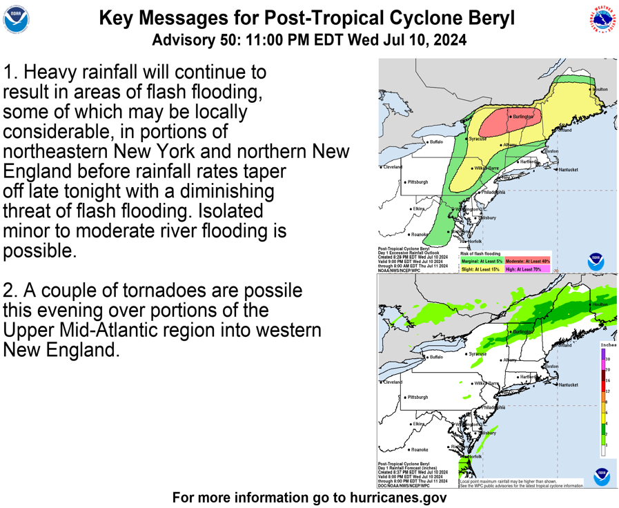
 Key Messages
Zoomed In Watches and Warnings

Additional Projected Path Swath
Key Messages
Zoomed In Watches and Warnings
Additional Projected Path Swath
Current Satellite
Current Wind Field


Wind Probs/ Hurricane Force Winds
 Most Likely Arrival Time of Tropical Storm Force Winds
 Most Reasonable Arrival Time of Tropical Storm Force Winds
 Hurricane Force Wind Probabilities
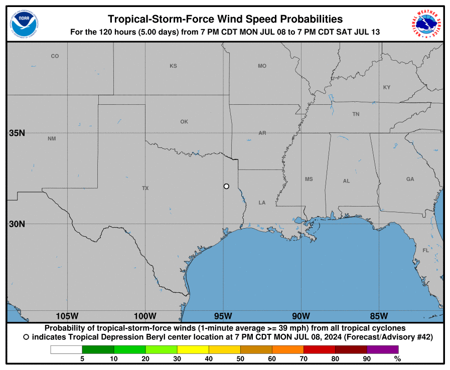
 Tropical Storm Force Wind Probabilities
Most Likely Arrival Time of Tropical Storm Force Winds
Most Reasonable Arrival Time of Tropical Storm Force Winds
Hurricane Force Wind Probabilities
Tropical Storm Force Wind Probabilities
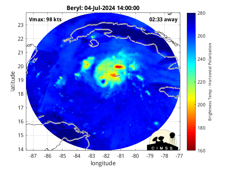
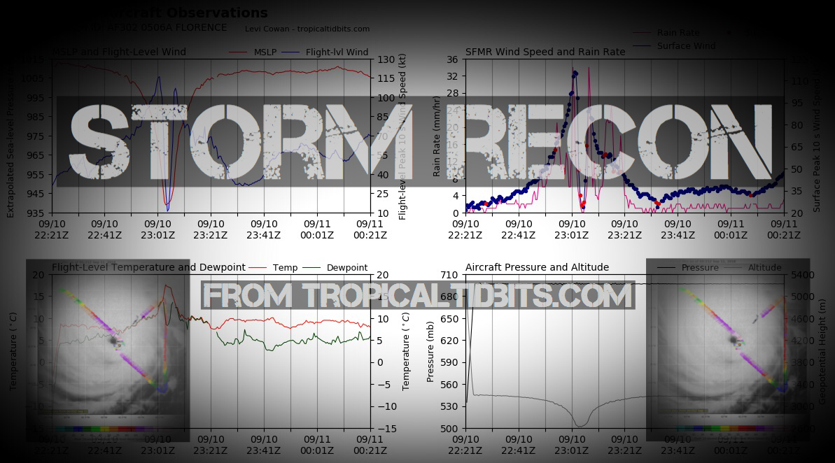
Microwave Imagery
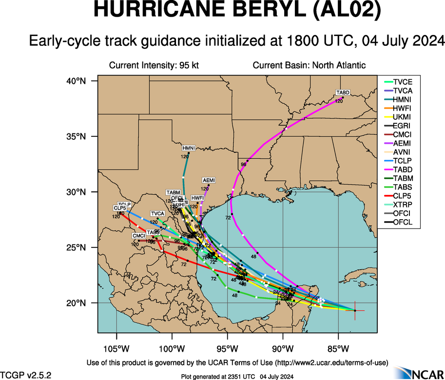
Latest Intensity Models
 Latest Model Tracks

Latest Model Tracks
Rainfall Forecast

Sea Surface Temps Around Storm

Windshear Around Storm

Ocean Heat Content (OHC) Around Storm
Saharan Dust Layer (SAL) around Storm

Surface Pressure and Rainfall around Storm

Windshear Around Storm
Ocean Heat Content (OHC) Around Storm
Saharan Dust Layer (SAL) around Storm
Surface Pressure and Rainfall around Storm

Top Analog Tracks


WeatherNerds.org Floaters
Other Floater Sites:
TropicalTidbits - NRL Floaters - CyclonicWx - RAMMB Sat - RAMMB Model Data - RAMMB Wind Products

|

|

|

|
TropicalTidbits - NRL Floaters - CyclonicWx - RAMMB Sat - RAMMB Model Data - RAMMB Wind Products
Average Days For System To Reach U.S.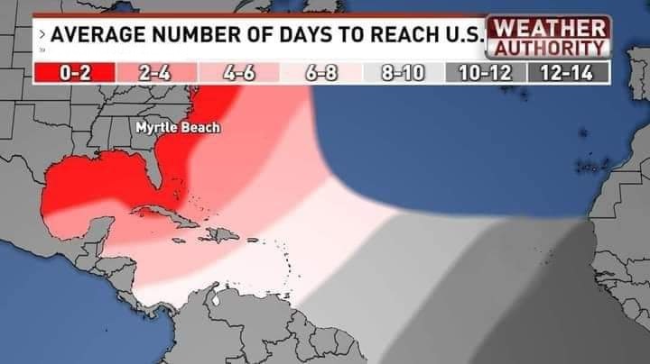
Other Model / Ensemble Tracks
 EURO Ensemble Tracks
 GFS Ensemble Tracks

Invest 94L CMC Ensemble Tracks
EURO Ensemble Tracks
GFS Ensemble Tracks
Invest 94L CMC Ensemble Tracks
- Thu, 04 Jul 2024 17:44:02 +0000: Atlantic Hurricane Beryl Intermediate Advisory Number 24A - Atlantic Hurricane Beryl Intermediate Advisory Number 24A
000
WTNT32 KNHC 041743
TCPAT2
BULLETIN
Hurricane Beryl Intermediate Advisory Number 24A
NWS National Hurricane Center Miami FL AL022024
200 PM EDT Thu Jul 04 2024
...CENTER OF BERYL MOVING ACROSS THE NORTHWESTERN CARIBBEAN SEA...
...STRONG WINDS, DANGEROUS STORM SURGE, AND DAMAGING WAVES EXPECTED
ON THE COAST OF THE YUCATAN PENINSULA OF MEXICO BY EARLY FRIDAY...
SUMMARY OF 200 PM EDT...1800 UTC...INFORMATION
----------------------------------------------
LOCATION...19.2N 83.4W
ABOUT 135 MI...215 KM W OF GRAND CAYMAN
ABOUT 275 MI...445 KM ESE OF TULUM MEXICO
MAXIMUM SUSTAINED WINDS...110 MPH...175 KM/H
PRESENT MOVEMENT...WNW OR 285 DEGREES AT 18 MPH...30 KM/H
MINIMUM CENTRAL PRESSURE...974 MB...28.76 INCHES
WATCHES AND WARNINGS
--------------------
CHANGES WITH THIS ADVISORY:
The Meteorological Service of the Cayman Islands has discontinued
all warnings for the Cayman Islands.
SUMMARY OF WATCHES AND WARNINGS IN EFFECT:
A Hurricane Warning is in effect for...
* The coast of the Yucatan Peninsula of Mexico from Puerto Costa
Maya to Cancun, including Cozumel
A Hurricane Watch is in effect for...
* The coast of the Yucatan Peninsula of Mexico south of Puerto
Costa Maya to Chetumal
* The coast of the Yucatan Peninsula of Mexico north of Cancun to
Cabo Catoche
A Tropical Storm Warning is in effect for...
* The coast of the Yucatan Peninsula of Mexico south of Puerto
Costa Maya to Chetumal
* The coast of the Yucatan Peninsula of Mexico north of Cancun to
Campeche
A Tropical Storm Watch is in effect for...
* Coast of Belize from south of Chetumal to Belize City
A Hurricane Warning means that hurricane conditions are expected
somewhere within the warning area. Preparations to protect life
and property should be rushed to completion.
A Tropical Storm Warning means that tropical storm conditions are
expected somewhere within the warning area, in this case within
24 hours.
A Hurricane Watch means that hurricane conditions are possible
within the watch area.
A Tropical Storm Watch means that tropical storm conditions are
possible within the watch area.
Interests elsewhere in the northwestern Caribbean Sea and the
western Gulf of Mexico, including southern Texas and northeastern
Mexico, should closely monitor the progress of Beryl.
For storm information specific to your area, please monitor
products issued by your national meteorological service.
DISCUSSION AND OUTLOOK
----------------------
At 200 PM EDT (1800 UTC), the center of Hurricane Beryl was located
near latitude 19.2 North, longitude 83.4 West. Beryl is moving
toward the west-northwest near 18 mph (30 km/h). A westward to west-
northwestward motion is expected during the next day or two, taking
the core of Beryl away from the Cayman Islands through this
afternoon and then over the Yucatan Peninsula early Friday. Beryl is
expected to emerge over the southwestern Gulf of Mexico Friday night
and move northwestward across the southwestern Gulf of Mexico on
Saturday.
Reports from Air Force Reserve Hurricane Hunter aircraft indicate
that maximum sustained winds are now near 110 mph (175 km/h) with
higher gusts. Beryl is a category 2 hurricane on the
Saffir-Simpson Hurricane Wind Scale. Weakening is forecast during
the next day or two, though Beryl is forecast to remain a hurricane
until it makes landfall on the Yucatan Peninsula.
Hurricane-force winds extend outward up to 30 miles (45 km) from
the center and tropical-storm-force winds extend outward up to 160
miles (260 km).
The latest minimum central pressure estimated from Air Force
Reserve Hurricane Hunter data is 974 mb (28.76 inches).
HAZARDS AFFECTING LAND
----------------------
Key messages for Beryl can be found in the Tropical Cyclone
Discussion under AWIPS header MIATCDAT2 and WMO header WTNT42 KNHC.
WIND: Hurricane conditions are expected in the hurricane warning
area on the Yucatan Peninsula tonight or early Friday. Winds are
expected to first reach tropical storm strength later today, making
outside preparations difficult or dangerous.
Hurricane conditions are possible in the hurricane watch area along
the east coast of the Yucatan Peninsula as early as tonight.
Tropical storm conditions are expected in the tropical storm warning
area of the Yucatan Peninsula late today.
Tropical storm conditions are possible in the tropical storm watch
area along portions of the coast of Belize by tonight or early
Friday.
Winds may gust to tropical-storm force in squalls in the Cayman
Islands during the next few hours.
STORM SURGE: Storm surge could raise water levels by as much as 3 to
5 feet above ground level in areas of onshore winds along the east
coast of the Yucatan Peninsula within the hurricane warning area
and by as much as 1 to 3 feet above ground level along the west
coast of the Yucatan Peninsula in the tropical storm warning area.
Near the coast, the surge will be accompanied by large and
destructive waves.
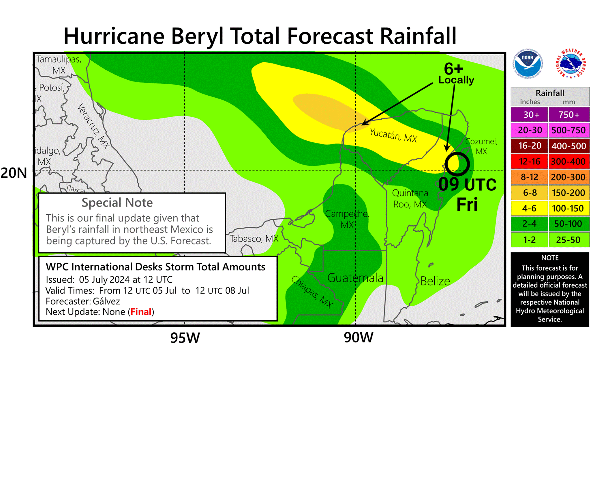
RAINFALL: Beryl is expected to produce rainfall totals of 4 to 6
inches over the Cayman Islands today. Over the Yucatan Peninsula,
Beryl is expected to produce rainfall totals of 4 to 6 inches, with
localized amounts of 10 inches, later today into Friday. Scattered
instances of flash flooding are anticipated.
For a complete depiction of forecast rainfall and flash flooding
associated with Hurricane Beryl, please see the National Weather
Service Storm Total Rainfall Graphic, available at
hurricanes.gov/graphics_at2.shtml?rainqpf
SURF: Large swells generated by Beryl are currently impacting
portions of the coast of Jamaica, Cuba, and the Cayman Islands.
These swells are expected to spread to the Yucatan Peninsula and
portions of Central America later today and to eastern Mexico and
much of the Gulf Coast of the U.S. by late Friday. These swells are
expected to cause life-threatening surf and rip current conditions.
Please consult products from your local weather office.
NEXT ADVISORY
-------------
Next complete advisory at 500 PM EDT.
$$
Forecaster Beven
- Thu, 04 Jul 2024 14:43:57 +0000: Atlantic Hurricane BERYL Forecast/Advisory Number ... - Atlantic Hurricane BERYL Forecast/Advisory Number 24 NWS NATIONAL HURRICANE CENTER MIAMI FL AL022024 1500 UTC THU JUL 04 2024 HURRICANE CENTER LOCATED NEAR 19.0N 82.6W AT 04/1500Z POSITION ACCURATE WITHIN 20 NM PRESENT MOVEMENT TOWARD THE WEST-NORTHWEST OR 285 DEGREES AT 16 KT ESTIMATED MINIMUM CENTRAL PRESSURE 971 MB MAX SUSTAINED WINDS 100 KT WITH GUSTS TO 120 KT. 64 KT....... 25NE 15SE 15SW 25NW. 50 KT....... 50NE 40SE 30SW 50NW. 34 KT.......140NE 80SE 50SW 100NW. 12 FT SEAS..180NE 120SE 60SW 150NW. WINDS AND SEAS VARY GREATLY IN EACH QUADRANT. RADII IN NAUTICAL MILES ARE THE LARGEST RADII EXPECTED ANYWHERE IN THAT QUADRANT. REPEAT...CENTER LOCATED NEAR 19.0N 82.6W AT 04/1500Z AT 04/1200Z CENTER WAS LOCATED NEAR 18.8N 81.8W FORECAST VALID 05/0000Z 19.5N 85.1W MAX WIND 90 KT...GUSTS 110 KT. 64 KT... 25NE 15SE 15SW 25NW. 50 KT... 50NE 40SE 30SW 50NW. 34 KT...130NE 70SE 50SW 100NW. FORECAST VALID 05/1200Z 20.1N 87.9W...INLAND MAX WIND 70 KT...GUSTS 85 KT. 64 KT... 20NE 10SE 10SW 20NW. 50 KT... 50NE 30SE 20SW 40NW. 34 KT...120NE 60SE 40SW 90NW. FORECAST VALID 06/0000Z 20.9N 90.3W...INLAND MAX WIND 50 KT...GUSTS 60 KT. 50 KT... 30NE 0SE 0SW 0NW. 34 KT...110NE 40SE 30SW 70NW. FORECAST VALID 06/1200Z 22.0N 92.4W...OVER WATER MAX WIND 50 KT...GUSTS 60 KT. 50 KT... 30NE 0SE 0SW 30NW. 34 KT...100NE 40SE 40SW 80NW. FORECAST VALID 07/0000Z 23.0N 94.2W MAX WIND 55 KT...GUSTS 65 KT. 50 KT... 30NE 20SE 0SW 30NW. 34 KT...100NE 60SE 50SW 90NW. FORECAST VALID 07/1200Z 23.9N 95.7W MAX WIND 60 KT...GUSTS 75 KT. 50 KT... 30NE 20SE 0SW 30NW. 34 KT...100NE 60SE 60SW 90NW. EXTENDED OUTLOOK. NOTE...ERRORS FOR TRACK HAVE AVERAGED NEAR 125 NM ON DAY 4 AND 175 NM ON DAY 5...AND FOR INTENSITY NEAR 15 KT EACH DAY OUTLOOK VALID 08/1200Z 25.5N 97.5W...INLAND MAX WIND 65 KT...GUSTS 80 KT. 50 KT... 40NE 30SE 20SW 20NW. 34 KT... 90NE 60SE 50SW 60NW. OUTLOOK VALID 09/1200Z 28.0N 99.5W...INLAND MAX WIND 30 KT...GUSTS 40 KT. REQUEST FOR 3 HOURLY SHIP REPORTS WITHIN 300 MILES OF 19.0N 82.6W Intermediate PUBLIC Advisory...WTNT32 KNHC/MIATCPAT2...AT 04/1800Z NEXT ADVISORY AT 04/2100Z $$ FORECASTER BEVEN
000
WTNT22 KNHC 041443
TCMAT2
HURRICANE BERYL FORECAST/ADVISORY NUMBER 24
NWS NATIONAL HURRICANE CENTER MIAMI FL AL022024
1500 UTC THU JUL 04 2024
HURRICANE CENTER LOCATED NEAR 19.0N 82.6W AT 04/1500Z
POSITION ACCURATE WITHIN 20 NM
PRESENT MOVEMENT TOWARD THE WEST-NORTHWEST OR 285 DEGREES AT 16 KT
ESTIMATED MINIMUM CENTRAL PRESSURE 971 MB
MAX SUSTAINED WINDS 100 KT WITH GUSTS TO 120 KT.
64 KT....... 25NE 15SE 15SW 25NW.
50 KT....... 50NE 40SE 30SW 50NW.
34 KT.......140NE 80SE 50SW 100NW.
12 FT SEAS..180NE 120SE 60SW 150NW.
WINDS AND SEAS VARY GREATLY IN EACH QUADRANT. RADII IN NAUTICAL
MILES ARE THE LARGEST RADII EXPECTED ANYWHERE IN THAT QUADRANT.
REPEAT...CENTER LOCATED NEAR 19.0N 82.6W AT 04/1500Z
AT 04/1200Z CENTER WAS LOCATED NEAR 18.8N 81.8W
FORECAST VALID 05/0000Z 19.5N 85.1W
MAX WIND 90 KT...GUSTS 110 KT.
64 KT... 25NE 15SE 15SW 25NW.
50 KT... 50NE 40SE 30SW 50NW.
34 KT...130NE 70SE 50SW 100NW.
FORECAST VALID 05/1200Z 20.1N 87.9W...INLAND
MAX WIND 70 KT...GUSTS 85 KT.
64 KT... 20NE 10SE 10SW 20NW.
50 KT... 50NE 30SE 20SW 40NW.
34 KT...120NE 60SE 40SW 90NW.
FORECAST VALID 06/0000Z 20.9N 90.3W...INLAND
MAX WIND 50 KT...GUSTS 60 KT.
50 KT... 30NE 0SE 0SW 0NW.
34 KT...110NE 40SE 30SW 70NW.
FORECAST VALID 06/1200Z 22.0N 92.4W...OVER WATER
MAX WIND 50 KT...GUSTS 60 KT.
50 KT... 30NE 0SE 0SW 30NW.
34 KT...100NE 40SE 40SW 80NW.
FORECAST VALID 07/0000Z 23.0N 94.2W
MAX WIND 55 KT...GUSTS 65 KT.
50 KT... 30NE 20SE 0SW 30NW.
34 KT...100NE 60SE 50SW 90NW.
FORECAST VALID 07/1200Z 23.9N 95.7W
MAX WIND 60 KT...GUSTS 75 KT.
50 KT... 30NE 20SE 0SW 30NW.
34 KT...100NE 60SE 60SW 90NW.
EXTENDED OUTLOOK. NOTE...ERRORS FOR TRACK HAVE AVERAGED NEAR 125 NM
ON DAY 4 AND 175 NM ON DAY 5...AND FOR INTENSITY NEAR 15 KT EACH DAY
OUTLOOK VALID 08/1200Z 25.5N 97.5W...INLAND
MAX WIND 65 KT...GUSTS 80 KT.
50 KT... 40NE 30SE 20SW 20NW.
34 KT... 90NE 60SE 50SW 60NW.
OUTLOOK VALID 09/1200Z 28.0N 99.5W...INLAND
MAX WIND 30 KT...GUSTS 40 KT.
REQUEST FOR 3 HOURLY SHIP REPORTS WITHIN 300 MILES OF 19.0N 82.6W
INTERMEDIATE PUBLIC ADVISORY...WTNT32 KNHC/MIATCPAT2...AT 04/1800Z
NEXT ADVISORY AT 04/2100Z
$$
FORECASTER BEVEN
- Thu, 04 Jul 2024 14:45:28 +0000: Atlantic Hurricane Beryl Discussion Number 24 - Atlantic Hurricane Beryl Discussion Number 24
000
WTNT42 KNHC 041445
TCDAT2
Hurricane Beryl Discussion Number 24
NWS National Hurricane Center Miami FL AL022024
1100 AM EDT Thu Jul 04 2024
Beryl continues to weaken due to the effects of westerly shear.
Radar data from the Cayman Islands shows that the eyewall is open
to the south and that there is very little precipitation occurring
in the southwestern semicircle. This matches the asymmetric cloud
pattern seen in satellite imagery. Data from the NOAA and Air
Force Reserve Hurricane Hunters support surface winds of 90-100 kt,
and that the central pressure has risen to near 971 mb. Based on
this, the initial intensity is reduced to a possibly generous 100
kt. The initial wind radii have be modified downward based on the
aircraft data.
The initial motion is 285/16. There is little change in either the
track forecast philosophy or the track forecast from the previous
advisory. A large ridge centered over the southeastern U.S. should
cause Beryl to move westward or west-northwestward during the next
day or two, with the model guidance tightly clustered about a
landfall on the Yucatan Peninsula just before 24 h and emerging into
the southwestern Gulf of Mexico just after 36 h. After that, Beryl
should turn northwest toward a developing break in the subtropical
ridge caused by a mid-latitude trough over the central United
States. This general motion should continue until the cyclone makes
landfall on the western Gulf coast near 96 h. While the guidance
has come into better agreement, there is a spread in the guidance
landfall points from northeastern Mexico to the middle Texas coast,
and users are reminded that the average error at day 4 is about 150
miles. Thus, it is still too early to pinpoint a specific region
for the worst hazards. The new official forecast is similar to, but
a touch slower than, the previous forecast and it lies close to the
consensus models.
Water vapor imagery continues to show a upper-level trough moving
west-southwestward over the southern Gulf of Mexico, with
westerly flow on the south side of this system helping to impart
moderate-to-strong shear over Beryl. While the shear could
decrease some during the next 24 h, it is unlikely to decrease
enough to stop Beryl from steadily weakening until landfall on the
Yucatan Peninsula. This part of the new intensity forecast follows
the trend of the intensity guidance. Beryl should weaken more
after landfall. There is uncertainty in how much shear the cyclone
may encounter over the Gulf of Mexico, but the guidance shows slow
intensification during that time. This is reflected in the new
intensity forecast that brings the system back to hurricane strength
right at landfall on the western Gulf coast.
Key Messages:
1. Strong winds, dangerous storm surge, damaging waves, and areas of
flooding are occurring in the Cayman Islands where a Hurricane
Warning remains in effect.
2. Hurricane-force winds, dangerous storm surge, and heavy rainfall
are expected over portions of the Yucatan Peninsula beginning
tonight as Beryl approaches that area as a hurricane. Hurricane and
Tropical Storm Warnings are in effect for portions of that area.
3. There is an increasing risk of strong winds, storm surge, and
heavy rainfall in portions of northeastern Mexico and southern Texas
later this weekend. Interests in these areas should closely monitor
the progress of Beryl and updates to the forecast.
4. Rip currents could cause life-threatening beach conditions
beginning late Friday and continuing through the weekend across much
of the Gulf coast.
FORECAST POSITIONS AND MAX WINDS
INIT 04/1500Z 19.0N 82.6W 100 KT 115 MPH
12H 05/0000Z 19.5N 85.1W 90 KT 105 MPH
24H 05/1200Z 20.1N 87.9W 70 KT 80 MPH...INLAND
36H 06/0000Z 20.9N 90.3W 50 KT 60 MPH...INLAND
48H 06/1200Z 22.0N 92.4W 50 KT 60 MPH...OVER WATER
60H 07/0000Z 23.0N 94.2W 55 KT 65 MPH
72H 07/1200Z 23.9N 95.7W 60 KT 70 MPH
96H 08/1200Z 25.5N 97.5W 65 KT 75 MPH...INLAND
120H 09/1200Z 28.0N 99.5W 30 KT 35 MPH...INLAND
$$
Forecaster Beven
2 Day Tropical Weather Outlook
7 Day Tropical Weather Outlook