2018 Hurricane Season Forecasts
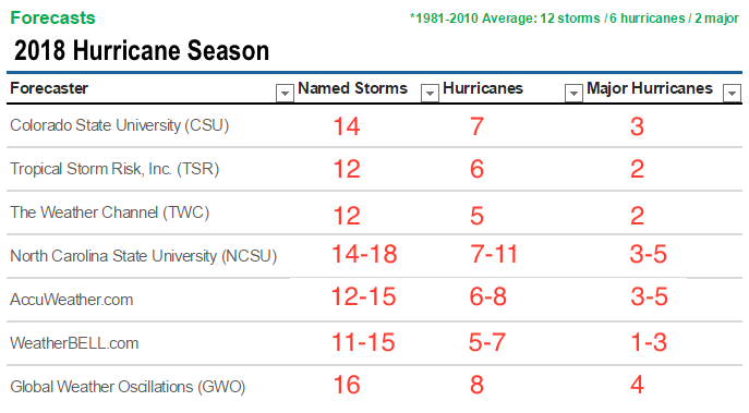
2018 Hurricane Season Forecasts The 2018 hurricane season begins June 1. Most initial forecasts project that the number of storms will be above average, and several forecasts indicate an above-average likelihood that a major hurricane will make landfall in the Caribbean, the Gulf Coast, or the US East Coast. For residents still picking up after […]
2018 Atlantic Hurricane Season Officially Ends
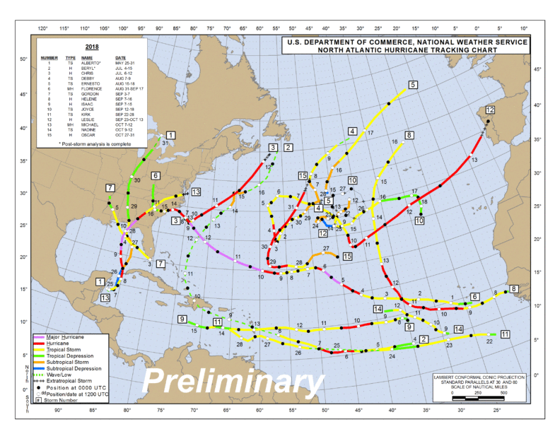
2018 Atlantic Hurricane Season Officially Ends The 2018 Atlantic hurricane season is OVER! Despite almost all major forecasting groups calling for a BELOW average season this year was actually an ABOVE average season and was the third consecutive above-average damaging season. These groups were banking on cooler than normal sea surface temperatures in the tropical […]
2019 Hurricane Season Forecasts
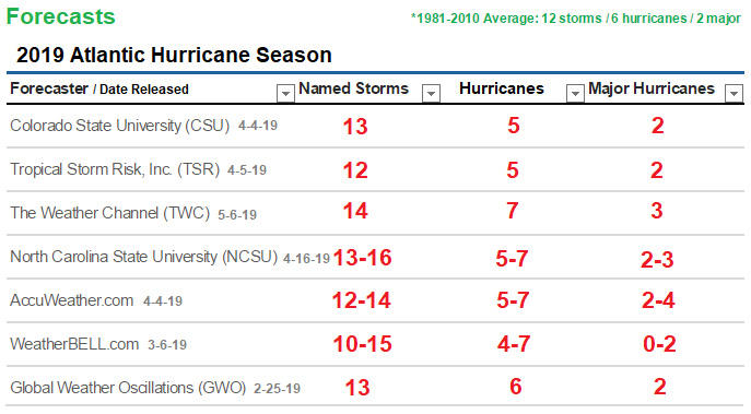
2019 Hurricane Season Forecasts The 2019 hurricane season begins June 1st! Before the 2018 hurricane season started, Most forecasting groups called for a below-average season due to cooler than normal sea surface temperatures in the tropical Atlantic and the anticipated development of an El Niño. However, the anticipated El Niño failed to develop in time […]
2019 Active Hurricane Season Comes To An End
2019 Active Hurricane Season Comes To An End The 2019 Season has offically come to an end. The Season as far as numbers go was an active above average one. It was marked by tropical activity that churned busily from mid-August through October. The season produced 18 named storms, including six hurricanes of which three […]
2020 Hurricane Season Forecasts

2020 Hurricane Season Forecasts – Published April 30, 2020 – Updated: May 9, 2020 (Accuweather update) – Updated: May 21, 2020 (NOAA Forecast below) The 2020 hurricane season begins June 1st! May 1st, 2020 – The official start of the 2020 Atlantic Hurricane Season is now a month away and ALL major organizations are forecasting […]
2021 Atlantic Hurricane Season Forecasts
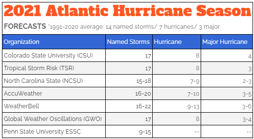
2021 Atlantic Hurricane Season Forecasts The 2021 hurricane season begins June 1st! April 28, 2021 – The official start of the 2021 Atlantic Hurricane Season is now a month away and just like in 2020 MOST major organizations are forecasting an ABOVE AVERAGE ACTIVE Season! The only organization not forecasting an above average season is […]